Murafa geodata
Murafa (Vinnyts'ka) is a populated place; located in Ukraine in Europe/Kiev (GMT+3) time zone. With population of 2,739 people, there are 998 cities with bigger population in this country. Compared to other cities in Ukraine, 61.6% of cities are located further ↓South; 75.3% of cities are located further →East and 76.8% of cities have lower elevation than Murafa. Note1


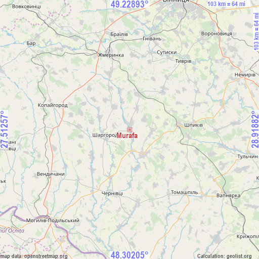
Murafa GPS coordinates[2]
48° 46' 3.468" North, 28° 12' 56.484" East
| Map corner | latitude | longitude |
|---|---|---|
| Upper-left | 49.22893°, | 27.51257° |
| Center: | 48.76763°, | 28.21569° |
| Lower-right: | 48.30205°, | 28.91882° |
| Map W x H: | 103.1×103.1 km | = 64.1×64.1mi |
| max Lat: | 52.18903° ⇑38.4% North |
| Murafa: | 48.76763° |
| min Lat: | ⇓61.6% South 44.39214° |
| min Long | Murafa | max Long |
| 22.20555° | 28.21569° | 40.13222° |
| W 24.7%⇐ | ⇒75.3% E |
Elevation
Elevation of Murafa is 233 m = 764 ft, and this is 77.2 m = 253 ft above average elevation for this country.
| Max E: |
886 m = 2907 ft | 23.2% |
| Murafa | 233 m 764 ft | |
| Avg. | 155.8 m = 511 ft | |
Min E: |
-3 m = -10 ft | 76.8% |
See also: Ukraine elevation on elevation.city.
Geographical zone
Murafa is located in North temperate zone (between Tropic of Cancer and the Arctic Circle). Distance of this North polar circle is 1978.7 km =1229.5 mi to North.| Distance of | km | miles | from Murafa |
|---|---|---|---|
| North Pole | 4584.6 | 2848.7 | to North |
| Arctic Circle | 1978.7 | 1229.5 | to North |
| Tropic Cancer | 2816.5 | 1750.1 | to South |
| Equator | 5422.5 | 3369.4 | to South |


Nearby cities:
15 places around Murafa: (largest is in red/bold)
• Brailiv
38.2 km =23.7 mi,  355°
355°
• Chernivtsi
26.1 km =16.2 mi,  196°
196°
• Klembivka
44.3 km =27.5 mi,  161°
161°
• Kopayhorod
32.3 km =20.1 mi,  288°
288°
• Mohyliv-Podilskyi
47.1 km =29.3 mi,  220°
220°
• Nemyriv
50.8 km =31.6 mi,  63°
63°
• Serebriya
50.3 km =31.3 mi,  226°
226°
• Sharhorod
10.4 km =6.5 mi,  262°
262°
• Sutysky
33.9 km =21.1 mi,  25°
25°
• Tomashpil’
33.4 km =20.8 mi,  138°
138°
• Tulchyn
47.4 km =29.5 mi,  102°
102°
• Tyvriv
34.8 km =21.6 mi,  37°
37°
• Vapnyarka
46.6 km =29 mi,  123°
123°
• Vendychany
35.5 km =22.1 mi,  240°
240°
• Zhmerynka
30.9 km =19.2 mi,  345°
345°
Sources, notices
• [Note1] Compared only with cities in Ukraine existing in our database
• [Src1] Map data: © OpenStreetMap contributors (CC-BY-SA)
• [Src2] Other city data from geonames.org with taken over terms of usage.
• [Src3] Geographical zone / Annual Mean Temperature by Robert A. Rohde @ Wikipedia
