Khmilnyk geodata
Khmilnyk (Vinnyts'ka) is a populated place; located in Ukraine in Europe/Kiev (GMT+3) time zone. With population of 28,136 people, there are 151 cities with bigger population in this country. Compared to other cities in Ukraine, 75.7% of cities are located further ↓South; 76.1% of cities are located further →East and 83.7% of cities have lower elevation than Khmilnyk. Note1


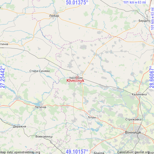
Khmilnyk GPS coordinates[2]
49° 33' 35.244" North, 27° 57' 27.144" East
| Map corner | latitude | longitude |
|---|---|---|
| Upper-left | 50.01375°, | 27.25442° |
| Center: | 49.55979°, | 27.95754° |
| Lower-right: | 49.10157°, | 28.66067° |
| Map W x H: | 101.4×101.4 km | = 63×63mi |
| max Lat: | 52.18903° ⇑24.3% North |
| Khmilnyk: | 49.55979° |
| min Lat: | ⇓75.7% South 44.39214° |
| min Long | Khmilnyk | max Long |
| 22.20555° | 27.95754° | 40.13222° |
| W 23.9%⇐ | ⇒76.1% E |
Elevation
Elevation of Khmilnyk is 266 m = 873 ft, and this is 110.2 m = 362 ft above average elevation for this country.
| Max E: |
886 m = 2907 ft | 16.3% |
| Khmilnyk | 266 m 873 ft | |
| Avg. | 155.8 m = 511 ft | |
Min E: |
-3 m = -10 ft | 83.7% |
See also: Ukraine elevation on elevation.city.
Geographical zone
Khmilnyk is located in North temperate zone (between Tropic of Cancer and the Arctic Circle). Distance of this North polar circle is 1890.6 km =1174.8 mi to North.| Distance of | km | miles | from Khmilnyk |
|---|---|---|---|
| North Pole | 4496.5 | 2794 | to North |
| Arctic Circle | 1890.6 | 1174.8 | to North |
| Tropic Cancer | 2904.6 | 1804.8 | to South |
| Equator | 5510.5 | 3424.1 | to South |


Nearby cities:
15 places around Khmilnyk: (largest is in red/bold)
• Bar
57.2 km =35.5 mi,  200°
200°
• Brailiv
52.4 km =32.6 mi,  162°
162°
• Chudniv
55.9 km =34.7 mi,  11°
11°
• Derazhnya
49.8 km =30.9 mi,  229°
229°
• Kalynivka
42.7 km =26.5 mi,  106°
106°
• Letychiv
30.8 km =19.1 mi, 230°
• Lityn
27.6 km =17.1 mi, 161°
• Liubar
42.6 km =26.5 mi,  340°
340°
• Medzhybizh
42.2 km =26.2 mi,  251°
251°
• Pavlivka
38.6 km =24 mi, 109°
• Sobolivka
56 km =34.8 mi,  116°
116°
• Stara Syniava
24.9 km =15.5 mi,  281°
281°
• Suslivtsi
26.1 km =16.2 mi,  238°
238°
• Ulaniv
19.6 km =12.2 mi,  40°
40°
• Vinnytsia
52.5 km =32.6 mi,  133°
133°
Sources, notices
• [Note1] Compared only with cities in Ukraine existing in our database
• [Src1] Map data: © OpenStreetMap contributors (CC-BY-SA)
• [Src2] Other city data from geonames.org with taken over terms of usage.
• [Src3] Geographical zone / Annual Mean Temperature by Robert A. Rohde @ Wikipedia
