Kalynivka geodata
Kalynivka (Vinnyts'ka) is a seat of a second-order administrative division; located in Ukraine in Europe/Kiev (GMT+3) time zone. With population of 19,315 people, there are 208 cities with bigger population in this country. Compared to other cities in Ukraine, 74% of cities are located further ↓South; 74.6% of cities are located further →East and 85.8% of cities have lower elevation than Kalynivka. Note1


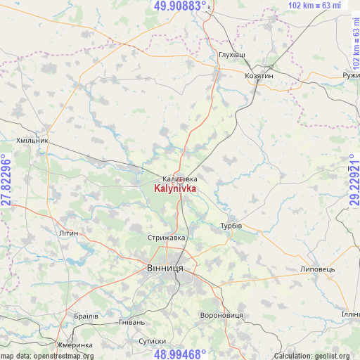
Kalynivka GPS coordinates[2]
49° 27' 14.004" North, 28° 31' 33.888" East
| Map corner | latitude | longitude |
|---|---|---|
| Upper-left | 49.90883°, | 27.82296° |
| Center: | 49.45389°, | 28.52608° |
| Lower-right: | 48.99468°, | 29.22921° |
| Map W x H: | 101.6×101.6 km | = 63.1×63.1mi |
| max Lat: | 52.18903° ⇑26% North |
| Kalynivka: | 49.45389° |
| min Lat: | ⇓74% South 44.39214° |
| min Long | Kalynivka | max Long |
| 22.20555° | 28.52608° | 40.13222° |
| W 25.4%⇐ | ⇒74.6% E |
Elevation
Elevation of Kalynivka is 280 m = 919 ft, and this is 124.2 m = 407 ft above average elevation for this country.
| Max E: |
886 m = 2907 ft | 14.2% |
| Kalynivka | 280 m 919 ft | |
| Avg. | 155.8 m = 511 ft | |
Min E: |
-3 m = -10 ft | 85.8% |
See also: Ukraine elevation on elevation.city.
Geographical zone
Kalynivka is located in North temperate zone (between Tropic of Cancer and the Arctic Circle). Distance of this North polar circle is 1902.4 km =1182.1 mi to North.| Distance of | km | miles | from Kalynivka |
|---|---|---|---|
| North Pole | 4508.3 | 2801.3 | to North |
| Arctic Circle | 1902.4 | 1182.1 | to North |
| Tropic Cancer | 2892.8 | 1797.5 | to South |
| Equator | 5498.8 | 3416.8 | to South |


Nearby cities:
15 places around Kalynivka: (largest is in red/bold)
• Brailiv
46 km =28.6 mi,  213°
213°
• Derhanivka
46.7 km =29 mi,  55°
55°
• Khmilnyk
42.7 km =26.5 mi,  286°
286°
• Kozyatyn
36.5 km =22.7 mi,  37°
37°
• Lityn
35.3 km =21.9 mi,  246°
246°
• Lypovets
45.7 km =28.4 mi,  123°
123°
• Nova Pryluka
15.3 km =9.5 mi, 124°
• Pavlivka
5 km =3.1 mi, 253°
• Sobolivka
15.9 km =9.9 mi,  145°
145°
• Sutysky
46.4 km =28.8 mi,  189°
189°
• Turbiv
18.4 km =11.4 mi,  129°
129°
• Tyvriv
48.9 km =30.4 mi,  181°
181°
• Ulaniv
39 km =24.2 mi,  313°
313°
• Vinnytsia
24.8 km =15.4 mi, 187°
• Voronovytsya
39.9 km =24.8 mi,  163°
163°
Sources, notices
• [Note1] Compared only with cities in Ukraine existing in our database
• [Src1] Map data: © OpenStreetMap contributors (CC-BY-SA)
• [Src2] Other city data from geonames.org with taken over terms of usage.
• [Src3] Geographical zone / Annual Mean Temperature by Robert A. Rohde @ Wikipedia
