Tsyurupyns’k geodata
Tsyurupyns’k (Kherson) is a seat of a second-order administrative division; located in Ukraine in Europe/Kiev (GMT+3) time zone. With population of 28,800 people, there are 147 cities with bigger population in this country. Compared to other cities in Ukraine, 66.5% of cities are located further ↑North; 54.1% of cities are located further →East and 96.8% of cities have higher elevation than Tsyurupyns’k. Note1


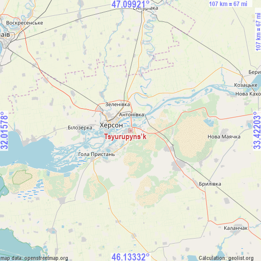
Tsyurupyns’k GPS coordinates[2]
46° 37' 6.312" North, 32° 43' 8.04" East
| Map corner | latitude | longitude |
|---|---|---|
| Upper-left | 47.09921°, | 32.01578° |
| Center: | 46.61842°, | 32.7189° |
| Lower-right: | 46.13332°, | 33.42203° |
| Map W x H: | 107.4×107.4 km | = 66.7×66.7mi |
| max Lat: | 52.18903° ⇑66.5% North |
| Tsyurupyns’k: | 46.61842° |
| min Lat: | ⇓33.5% South 44.39214° |
| min Long | Tsyurupyns’k | max Long |
| 22.20555° | 32.7189° | 40.13222° |
| W 45.9%⇐ | ⇒54.1% E |
Elevation
Elevation of Tsyurupyns’k is 9 m = 30 ft, and this is 146.8 m = 482 ft below average elevation for this country.
| Max E: |
886 m = 2907 ft | 96.8% |
| Avg. | 155.8 m = 511 ft | |
| Tsyurupyns’k | 9 m = 30 ft | |
Min E: |
-3 m = -10 ft | 3.2% |
See also: Ukraine elevation on elevation.city.
Geographical zone
Tsyurupyns’k is located in North temperate zone (between Tropic of Cancer and the Arctic Circle). Distance of this North polar circle is 2217.7 km =1378 mi to North.| Distance of | km | miles | from Tsyurupyns’k |
|---|---|---|---|
| North Pole | 4823.6 | 2997.2 | to North |
| Arctic Circle | 2217.7 | 1378 | to North |
| Tropic Cancer | 2577.6 | 1601.6 | to South |
| Equator | 5183.5 | 3220.9 | to South |


Nearby cities:
15 places around Tsyurupyns’k: (largest is in red/bold)
• Bilozerka
21.1 km =13.1 mi,  271°
271°
• Brylivka
39.2 km =24.4 mi,  123°
123°
• Chornobayivka
15.2 km =9.4 mi,  303°
303°
• Chulakivka
40.4 km =25.1 mi,  224°
224°
• Dnipryany
44.6 km =27.7 mi,  71°
71°
• Hola Prystan’
18 km =11.2 mi,  235°
235°
• Kherson
8.8 km =5.5 mi, 298°
• Komyshany
16.3 km =10.1 mi,  277°
277°
• Kozachi Laheri
21.9 km =13.6 mi,  64°
64°
• Nova Mayachka
38.9 km =24.2 mi,  93°
93°
• Oleksandrivka
24.7 km =15.3 mi,  7°
7°
• Radens’k
17.8 km =11.1 mi, 115°
• Stanislav
44 km =27.3 mi,  262°
262°
• Velyki Kopani
24.4 km =15.2 mi,  126°
126°
• Vynohradove
32.4 km =20.1 mi,  148°
148°
Sources, notices
• [Note1] Compared only with cities in Ukraine existing in our database
• [Src1] Map data: © OpenStreetMap contributors (CC-BY-SA)
• [Src2] Other city data from geonames.org with taken over terms of usage.
• [Src3] Geographical zone / Annual Mean Temperature by Robert A. Rohde @ Wikipedia
