Chulakivka geodata
Chulakivka (Kherson) is a populated place; located in Ukraine in Europe/Kiev (GMT+3) time zone. With population of 2,938 people, there are 963 cities with bigger population in this country. Compared to other cities in Ukraine, 67.7% of cities are located further ↑North; 56% of cities are located further →East and 91.7% of cities have higher elevation than Chulakivka. Note1


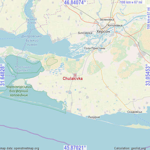
Chulakivka GPS coordinates[2]
46° 21' 27.468" North, 32° 21' 5.04" East
| Map corner | latitude | longitude |
|---|---|---|
| Upper-left | 46.84074°, | 31.64828° |
| Center: | 46.35763°, | 32.3514° |
| Lower-right: | 45.87021°, | 33.05453° |
| Map W x H: | 107.9×107.9 km | = 67×67mi |
| max Lat: | 52.18903° ⇑67.7% North |
| Chulakivka: | 46.35763° |
| min Lat: | ⇓32.3% South 44.39214° |
| min Long | Chulakivka | max Long |
| 22.20555° | 32.3514° | 40.13222° |
| W 44%⇐ | ⇒56% E |
Elevation
Elevation of Chulakivka is 17 m = 56 ft, and this is 138.8 m = 455 ft below average elevation for this country.
| Max E: |
886 m = 2907 ft | 91.7% |
| Avg. | 155.8 m = 511 ft | |
| Chulakivka | 17 m = 56 ft | |
Min E: |
-3 m = -10 ft | 8.3% |
See also: Ukraine elevation on elevation.city.
Geographical zone
Chulakivka is located in North temperate zone (between Tropic of Cancer and the Arctic Circle). Distance of this North polar circle is 2246.7 km =1396 mi to North.| Distance of | km | miles | from Chulakivka |
|---|---|---|---|
| North Pole | 4852.6 | 3015.3 | to North |
| Arctic Circle | 2246.7 | 1396 | to North |
| Tropic Cancer | 2548.6 | 1583.6 | to South |
| Equator | 5154.5 | 3202.9 | to South |


Nearby cities:
15 places around Chulakivka: (largest is in red/bold)
• Bekhtery
13 km =8.1 mi,  200°
200°
• Bilozerka
30.5 km =19 mi,  13°
13°
• Chornobayivka
40.5 km =25.2 mi,  22°
22°
• Hola Prystan’
23 km =14.3 mi,  35°
35°
• Kherson
38.9 km =24.2 mi,  31°
31°
• Komyshany
33.3 km =20.7 mi, 20°
• Krasne
40.8 km =25.4 mi,  128°
128°
• Lazurne
33.4 km =20.8 mi,  155°
155°
• Novofedorivka
20.9 km =13 mi,  187°
187°
• Radens’k
49 km =30.4 mi,  64°
64°
• Stanislav
28.2 km =17.5 mi,  326°
326°
• Tsyurupyns’k
40.4 km =25.1 mi, 44°
• Vynohradove
45.2 km =28.1 mi,  88°
88°
• Zaliznyy Port
26.4 km =16.4 mi, 188°
• Геройское
39.2 km =24.4 mi,  295°
295°
Sources, notices
• [Note1] Compared only with cities in Ukraine existing in our database
• [Src1] Map data: © OpenStreetMap contributors (CC-BY-SA)
• [Src2] Other city data from geonames.org with taken over terms of usage.
• [Src3] Geographical zone / Annual Mean Temperature by Robert A. Rohde @ Wikipedia
