Kherson geodata
Kherson is a seat of a first-order administrative division; located in Ukraine in Europe/Kiev (GMT+3) time zone. With population of 320,477 people, there are 16 cities with bigger population in this country. Compared to other cities in Ukraine, 66.1% of cities are located further ↑North; 54.6% of cities are located further →East and 77.9% of cities have higher elevation than Kherson. Note1


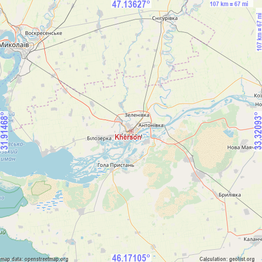
Kherson GPS coordinates[2]
46° 39' 20.916" North, 32° 37' 4.08" East
| Map corner | latitude | longitude |
|---|---|---|
| Upper-left | 47.13627°, | 31.91468° |
| Center: | 46.65581°, | 32.6178° |
| Lower-right: | 46.17105°, | 33.32093° |
| Map W x H: | 107.3×107.3 km | = 66.7×66.7mi |
| max Lat: | 52.18903° ⇑66.1% North |
| Kherson: | 46.65581° |
| min Lat: | ⇓33.9% South 44.39214° |
| min Long | Kherson | max Long |
| 22.20555° | 32.6178° | 40.13222° |
| W 45.4%⇐ | ⇒54.6% E |
Elevation
Elevation of Kherson is 51 m = 167 ft, and this is 104.8 m = 344 ft below average elevation for this country.
| Max E: |
886 m = 2907 ft | 77.9% |
| Avg. | 155.8 m = 511 ft | |
| Kherson | 51 m = 167 ft | |
Min E: |
-3 m = -10 ft | 22.1% |
See also: Kherson elevation on elevation.city.
Geographical zone
Kherson is located in North temperate zone (between Tropic of Cancer and the Arctic Circle). Distance of this North polar circle is 2213.5 km =1375.4 mi to North.| Distance of | km | miles | from Kherson |
|---|---|---|---|
| North Pole | 4819.4 | 2994.6 | to North |
| Arctic Circle | 2213.5 | 1375.4 | to North |
| Tropic Cancer | 2581.7 | 1604.2 | to South |
| Equator | 5187.6 | 3223.4 | to South |


Nearby cities:
15 places around Kherson: (largest is in red/bold)
• Bilozerka
13.8 km =8.6 mi,  255°
255°
• Brylivka
48 km =29.8 mi,  122°
122°
• Chornobayivka
6.5 km =4 mi,  311°
311°
• Chulakivka
38.9 km =24.2 mi,  211°
211°
• Hola Prystan’
16 km =9.9 mi, 206°
• Komyshany
8.7 km =5.4 mi, 256°
• Kozachi Laheri
28 km =17.4 mi,  79°
79°
• Nova Mayachka
46.9 km =29.1 mi,  97°
97°
• Oleksandrivka
23 km =14.3 mi,  28°
28°
• Radens’k
26.5 km =16.5 mi, 116°
• Shevchenkove
39 km =24.2 mi, 306°
• Stanislav
37.2 km =23.1 mi,  254°
254°
• Tsyurupyns’k
8.8 km =5.5 mi, 118°
• Velyki Kopani
33.1 km =20.6 mi, 124°
• Vynohradove
40.2 km =25 mi,  142°
142°
Sources, notices
• [Note1] Compared only with cities in Ukraine existing in our database
• [Src1] Map data: © OpenStreetMap contributors (CC-BY-SA)
• [Src2] Other city data from geonames.org with taken over terms of usage.
• [Src3] Geographical zone / Annual Mean Temperature by Robert A. Rohde @ Wikipedia
