Tenistoye geodata
Tenistoye (Republic of Crimea) is a seat of a third-order administrative division; located in Ukraine in Europe/Simferopol (GMT+3) time zone. With population of 1,211 people, there are 1292 cities with bigger population in this country. Compared to other cities in Ukraine, 96.4% of cities are located further ↑North; 54.8% of cities are located further ←West and 84% of cities have higher elevation than Tenistoye. Note1
Administrative division(s):
- Level 1: Republic of Crimea
- Level 2: Bakhchysarai Raion
- Level 3: Tenistovskoye sel'skoye poselenye


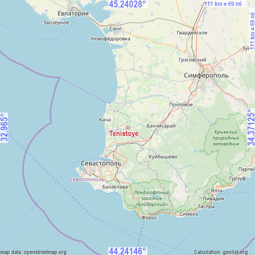
Tenistoye GPS coordinates[2]
44° 44' 34.908" North, 33° 40' 5.232" East
| Map corner | latitude | longitude |
|---|---|---|
| Upper-left | 45.24028°, | 32.965° |
| Center: | 44.74303°, | 33.66812° |
| Lower-right: | 44.24146°, | 34.37125° |
| Map W x H: | 111.1×111.1 km | = 69×69mi |
| max Lat: | 52.18903° ⇑96.4% North |
| Tenistoye: | 44.74303° |
| min Lat: | ⇓3.6% South 44.39214° |
| min Long | Tenistoye | max Long |
| 22.20555° | 33.66812° | 40.13222° |
| W 54.8%⇐ | ⇒45.2% E |
Elevation
Elevation of Tenistoye is 32 m = 105 ft, and this is 123.8 m = 406 ft below average elevation for this country.
| Max E: |
886 m = 2907 ft | 84% |
| Avg. | 155.8 m = 511 ft | |
| Tenistoye | 32 m = 105 ft | |
Min E: |
-3 m = -10 ft | 16% |
See also: Ukraine elevation on elevation.city.
Geographical zone
Tenistoye is located in North temperate zone (between Tropic of Cancer and the Arctic Circle). Distance of this Northern Tropic circle is 2369 km =1472 mi to South.| Distance of | km | miles | from Tenistoye |
|---|---|---|---|
| North Pole | 5032.1 | 3126.8 | to North |
| Arctic Circle | 2426.2 | 1507.6 | to North |
| Tropic Cancer | 2369 | 1472 | to South |
| Equator | 4975 | 3091.3 | to South |


Nearby cities:
15 places around Tenistoye: (largest is in red/bold)
• Dolinnoye
8.7 km =5.4 mi,  82°
82°
• Frontovoye
10.1 km =6.3 mi,  146°
146°
• Fruktovoye
8.8 km =5.5 mi,  216°
216°
• Furmanovka
6.3 km =3.9 mi,  74°
74°
• Kacha
10.5 km =6.5 mi,  290°
290°
• Noven’koye
10.3 km =6.4 mi,  93°
93°
• Orlovka
6.9 km =4.3 mi,  257°
257°
• Polyushko
6.2 km =3.9 mi,  269°
269°
• Solnechniy
6.3 km =3.9 mi,  320°
320°
• Suvorovo
3.3 km =2.1 mi,  252°
252°
• Uglovoye
10.1 km =6.3 mi,  330°
330°
• Verkhnesadovoye
6.5 km =4 mi,  155°
155°
• Vilino
11.4 km =7.1 mi,  1°
1°
• Vishnyovoye
5.1 km =3.2 mi, 256°
• Zheleznodorozhnoye
11.1 km =6.9 mi,  105°
105°
Sources, notices
• [Note1] Compared only with cities in Ukraine existing in our database
• [Src1] Map data: © OpenStreetMap contributors (CC-BY-SA)
• [Src2] Other city data from geonames.org with taken over terms of usage.
• [Src3] Geographical zone / Annual Mean Temperature by Robert A. Rohde @ Wikipedia
