Solnechniy geodata
Solnechniy (Sevastopol City) is a populated place; located in Ukraine in Europe/Simferopol (GMT+3) time zone. With population of 1,718 people, there are 1165 cities with bigger population in this country. Compared to other cities in Ukraine, 95.9% of cities are located further ↑North; 53.8% of cities are located further ←West and 68.3% of cities have higher elevation than Solnechniy. Note1
Administrative division(s):
- Level 1: Sevastopol City
- Level 2: Nakhimovskiy rayon
- Level 3: Andreevskiy munitsipal'niy okrug


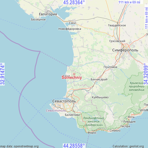
Solnechniy GPS coordinates[2]
44° 47' 12.372" North, 33° 37' 4.296" East
| Map corner | latitude | longitude |
|---|---|---|
| Upper-left | 45.28364°, | 32.91474° |
| Center: | 44.78677°, | 33.61786° |
| Lower-right: | 44.28558°, | 34.32099° |
| Map W x H: | 111×111 km | = 69×69mi |
| max Lat: | 52.18903° ⇑95.9% North |
| Solnechniy: | 44.78677° |
| min Lat: | ⇓4.1% South 44.39214° |
| min Long | Solnechniy | max Long |
| 22.20555° | 33.61786° | 40.13222° |
| W 53.8%⇐ | ⇒46.2% E |
Elevation
Elevation of Solnechniy is 80 m = 262 ft, and this is 75.8 m = 249 ft below average elevation for this country.
| Max E: |
886 m = 2907 ft | 68.3% |
| Avg. | 155.8 m = 511 ft | |
| Solnechniy | 80 m = 262 ft | |
Min E: |
-3 m = -10 ft | 31.7% |
See also: Ukraine elevation on elevation.city.
Geographical zone
Solnechniy is located in North temperate zone (between Tropic of Cancer and the Arctic Circle). Distance of this Northern Tropic circle is 2373.9 km =1475.1 mi to South.| Distance of | km | miles | from Solnechniy |
|---|---|---|---|
| North Pole | 5027.2 | 3123.8 | to North |
| Arctic Circle | 2421.4 | 1504.6 | to North |
| Tropic Cancer | 2373.9 | 1475.1 | to South |
| Equator | 4979.8 | 3094.3 | to South |


Nearby cities:
15 places around Solnechniy: (largest is in red/bold)
• Andreyevka
5.4 km =3.4 mi,  307°
307°
• Beregovoye
12.6 km =7.8 mi,  359°
359°
• Fruktovoye
11.9 km =7.4 mi,  186°
186°
• Furmanovka
10.5 km =6.5 mi,  107°
107°
• Kacha
6 km =3.7 mi,  258°
258°
• Orlovka
7 km =4.3 mi,  203°
203°
• Otradnoye
12.2 km =7.6 mi,  47°
47°
• Peschanoye
6.3 km =3.9 mi,  353°
353°
• Polyushko
5.5 km =3.4 mi, 204°
• Suvorovo
5.9 km =3.7 mi,  171°
171°
• Tenistoye
6.3 km =3.9 mi,  140°
140°
• Uglovoye
4 km =2.5 mi,  344°
344°
• Verkhnesadovoye
12.7 km =7.9 mi,  148°
148°
• Vilino
7.8 km =4.8 mi,  32°
32°
• Vishnyovoye
6.1 km =3.8 mi, 189°
Sources, notices
• [Note1] Compared only with cities in Ukraine existing in our database
• [Src1] Map data: © OpenStreetMap contributors (CC-BY-SA)
• [Src2] Other city data from geonames.org with taken over terms of usage.
• [Src3] Geographical zone / Annual Mean Temperature by Robert A. Rohde @ Wikipedia
