Uglovoye geodata
Uglovoye (Republic of Crimea) is a seat of a third-order administrative division; located in Ukraine in Europe/Simferopol (GMT+3) time zone. With population of 3,334 people, there are 862 cities with bigger population in this country. Compared to other cities in Ukraine, 95.3% of cities are located further ↑North; 53.2% of cities are located further ←West and 82.7% of cities have higher elevation than Uglovoye. Note1
Administrative division(s):
- Level 1: Republic of Crimea
- Level 2: Bakhchysarai Raion
- Level 3: Uglovskoye sel'skoye poselenye


Uglovoye GPS coordinates[2]
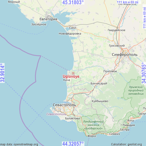
44° 49' 17.256" North, 33° 36' 16.272" East
| Map corner | latitude | longitude |
|---|---|---|
| Upper-left | 45.31803°, | 32.9014° |
| Center: | 44.82146°, | 33.60452° |
| Lower-right: | 44.32057°, | 34.30765° |
| Map W x H: | 110.9×110.9 km | = 68.9×68.9mi |
| max Lat: | 52.18903° ⇑95.3% North |
| Uglovoye: | 44.82146° |
| min Lat: | ⇓4.7% South 44.39214° |
| min Long | Uglovoye | max Long |
| 22.20555° | 33.60452° | 40.13222° |
| W 53.2%⇐ | ⇒46.8% E |
Elevation
Elevation of Uglovoye is 36 m = 118 ft, and this is 119.8 m = 393 ft below average elevation for this country.
| Max E: |
886 m = 2907 ft | 82.7% |
| Avg. | 155.8 m = 511 ft | |
| Uglovoye | 36 m = 118 ft | |
Min E: |
-3 m = -10 ft | 17.3% |
See also: Ukraine elevation on elevation.city.
Geographical zone
Uglovoye is located in North temperate zone (between Tropic of Cancer and the Arctic Circle). Distance of this Northern Tropic circle is 2377.8 km =1477.5 mi to South.| Distance of | km | miles | from Uglovoye |
|---|---|---|---|
| North Pole | 5023.4 | 3121.4 | to North |
| Arctic Circle | 2417.5 | 1502.2 | to North |
| Tropic Cancer | 2377.8 | 1477.5 | to South |
| Equator | 4983.7 | 3096.7 | to South |


Nearby cities:
15 places around Uglovoye: (largest is in red/bold)
• Andreyevka
3.3 km =2.1 mi,  260°
260°
• Beregovoye
8.8 km =5.5 mi,  6°
6°
• Furmanovka
13.1 km =8.1 mi,  122°
122°
• Kacha
6.9 km =4.3 mi,  223°
223°
• Orlovka
10.4 km =6.5 mi,  189°
189°
• Otradnoye
10.9 km =6.8 mi,  66°
66°
• Peschanoye
2.5 km =1.6 mi, 8°
• Polyushko
8.9 km =5.5 mi, 187°
• Shevchenkovo
13 km =8.1 mi, 69°
• Solnechniy
4 km =2.5 mi,  164°
164°
• Suvorovo
9.9 km =6.2 mi,  169°
169°
• Tabachnoye
10.6 km =6.6 mi,  32°
32°
• Tenistoye
10.1 km =6.3 mi,  150°
150°
• Vilino
5.9 km =3.7 mi,  63°
63°
• Vishnyovoye
9.9 km =6.2 mi,  179°
179°
Sources, notices
• [Note1] Compared only with cities in Ukraine existing in our database
• [Src1] Map data: © OpenStreetMap contributors (CC-BY-SA)
• [Src2] Other city data from geonames.org with taken over terms of usage.
• [Src3] Geographical zone / Annual Mean Temperature by Robert A. Rohde @ Wikipedia
