Fruktovoye geodata
Fruktovoye (Sevastopol City) is a populated place; located in Ukraine in Europe/Simferopol (GMT+3) time zone. With population of 744 people, there are 1513 cities with bigger population in this country. Compared to other cities in Ukraine, 97.4% of cities are located further ↑North; 53.1% of cities are located further ←West and 91.7% of cities have higher elevation than Fruktovoye. Note1
Administrative division(s):
- Level 1: Sevastopol City
- Level 2: Nakhimovskiy rayon
- Level 3: Verkhnesadovskiy munitsipal'niy okrug


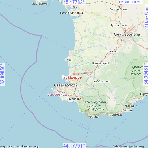
Fruktovoye GPS coordinates[2]
44° 40' 48.072" North, 33° 36' 6.048" East
| Map corner | latitude | longitude |
|---|---|---|
| Upper-left | 45.17782°, | 32.89856° |
| Center: | 44.68002°, | 33.60168° |
| Lower-right: | 44.17791°, | 34.30481° |
| Map W x H: | 111.2×111.2 km | = 69.1×69.1mi |
| max Lat: | 52.18903° ⇑97.4% North |
| Fruktovoye: | 44.68002° |
| min Lat: | ⇓2.6% South 44.39214° |
| min Long | Fruktovoye | max Long |
| 22.20555° | 33.60168° | 40.13222° |
| W 53.1%⇐ | ⇒46.9% E |
Elevation
Elevation of Fruktovoye is 17 m = 56 ft, and this is 138.8 m = 455 ft below average elevation for this country.
| Max E: |
886 m = 2907 ft | 91.7% |
| Avg. | 155.8 m = 511 ft | |
| Fruktovoye | 17 m = 56 ft | |
Min E: |
-3 m = -10 ft | 8.3% |
See also: Ukraine elevation on elevation.city.
Geographical zone
Fruktovoye is located in North temperate zone (between Tropic of Cancer and the Arctic Circle). Distance of this Northern Tropic circle is 2362 km =1467.7 mi to South.| Distance of | km | miles | from Fruktovoye |
|---|---|---|---|
| North Pole | 5039.1 | 3131.2 | to North |
| Arctic Circle | 2433.2 | 1511.9 | to North |
| Tropic Cancer | 2362 | 1467.7 | to South |
| Equator | 4968 | 3087 | to South |


Nearby cities:
15 places around Fruktovoye: (largest is in red/bold)
• Frontovoye
10.9 km =6.8 mi,  97°
97°
• Furmanovka
14.2 km =8.8 mi,  52°
52°
• Inkerman
7.4 km =4.6 mi,  175°
175°
• Kacha
11.6 km =7.2 mi,  336°
336°
• Kholmovka
12.3 km =7.6 mi, 101°
• Orlovka
5.7 km =3.5 mi, 344°
• Polyushko
7 km =4.3 mi,  351°
351°
• Sakharnaya Golovka
11.2 km =7 mi,  162°
162°
• Sevastopol
11.9 km =7.4 mi,  211°
211°
• Shturmovoye
12.6 km =7.8 mi,  172°
172°
• Solnechniy
11.9 km =7.4 mi,  6°
6°
• Suvorovo
6.4 km =4 mi,  19°
19°
• Tenistoye
8.8 km =5.5 mi,  36°
36°
• Verkhnesadovoye
8 km =5 mi,  82°
82°
• Vishnyovoye
5.8 km =3.6 mi,  2°
2°
Sources, notices
• [Note1] Compared only with cities in Ukraine existing in our database
• [Src1] Map data: © OpenStreetMap contributors (CC-BY-SA)
• [Src2] Other city data from geonames.org with taken over terms of usage.
• [Src3] Geographical zone / Annual Mean Temperature by Robert A. Rohde @ Wikipedia
