Volnovakha geodata
Volnovakha (Donetsk) is a seat of a second-order administrative division; located in Ukraine in Europe/Kiev (GMT+3) time zone. With population of 23,731 people, there are 173 cities with bigger population in this country. Compared to other cities in Ukraine, 60% of cities are located further ↑North; 92.5% of cities are located further ←West and 82.3% of cities have lower elevation than Volnovakha. Note1


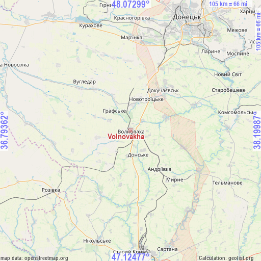
Volnovakha GPS coordinates[2]
47° 36' 3.708" North, 37° 29' 48.264" East
| Map corner | latitude | longitude |
|---|---|---|
| Upper-left | 48.07299°, | 36.79362° |
| Center: | 47.60103°, | 37.49674° |
| Lower-right: | 47.12477°, | 38.19987° |
| Map W x H: | 105.4×105.4 km | = 65.5×65.5mi |
| max Lat: | 52.18903° ⇑60% North |
| Volnovakha: | 47.60103° |
| min Lat: | ⇓40% South 44.39214° |
| min Long | Volnovakha | max Long |
| 22.20555° | 37.49674° | 40.13222° |
| W 92.5%⇐ | ⇒7.5% E |
Elevation
Elevation of Volnovakha is 260 m = 853 ft, and this is 104.2 m = 342 ft above average elevation for this country.
| Max E: |
886 m = 2907 ft | 17.7% |
| Volnovakha | 260 m 853 ft | |
| Avg. | 155.8 m = 511 ft | |
Min E: |
-3 m = -10 ft | 82.3% |
See also: Ukraine elevation on elevation.city.
Geographical zone
Volnovakha is located in North temperate zone (between Tropic of Cancer and the Arctic Circle). Distance of this North polar circle is 2108.4 km =1310.1 mi to North.| Distance of | km | miles | from Volnovakha |
|---|---|---|---|
| North Pole | 4714.3 | 2929.3 | to North |
| Arctic Circle | 2108.4 | 1310.1 | to North |
| Tropic Cancer | 2686.8 | 1669.5 | to South |
| Equator | 5292.7 | 3288.7 | to South |


Nearby cities:
15 places around Volnovakha: (largest is in red/bold)
• Blahodatne
12.5 km =7.8 mi,  332°
332°
• Boykivske
45 km =28 mi,  118°
118°
• Dianivka
21.2 km =13.2 mi,  200°
200°
• Dokuchayevs’k
21.5 km =13.4 mi,  39°
39°
• Donetsk
52.2 km =32.4 mi,  25°
25°
• Horbachevo-Mykhaylivka
47.2 km =29.3 mi,  53°
53°
• Kalynove
16.2 km =10.1 mi,  188°
188°
• Kurakhovo
45.6 km =28.3 mi,  339°
339°
• Mar'yinka
38.3 km =23.8 mi,  0°
0°
• Nikol's’ke
45.9 km =28.5 mi, 196°
• Novyy Svit
45.4 km =28.2 mi,  59°
59°
• Rozivka
40.2 km =25 mi,  233°
233°
• Sartana
49.7 km =30.9 mi,  162°
162°
• Starobesheve
43.3 km =26.9 mi,  67°
67°
• Staryy Krym
48.9 km =30.4 mi,  180°
180°
Sources, notices
• [Note1] Compared only with cities in Ukraine existing in our database
• [Src1] Map data: © OpenStreetMap contributors (CC-BY-SA)
• [Src2] Other city data from geonames.org with taken over terms of usage.
• [Src3] Geographical zone / Annual Mean Temperature by Robert A. Rohde @ Wikipedia
