Kalynove geodata
Kalynove (Donetsk) is a populated place; located in Ukraine in Europe/Kiev (GMT+3) time zone. With population of 577 people, there are 1603 cities with bigger population in this country. Compared to other cities in Ukraine, 61% of cities are located further ↑North; 92.3% of cities are located further ←West and 56% of cities have lower elevation than Kalynove. Note1


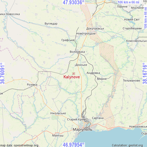
Kalynove GPS coordinates[2]
47° 27' 25.56" North, 37° 27' 50.508" East
| Map corner | latitude | longitude |
|---|---|---|
| Upper-left | 47.93036°, | 36.76091° |
| Center: | 47.4571°, | 37.46403° |
| Lower-right: | 46.97954°, | 38.16716° |
| Map W x H: | 105.7×105.7 km | = 65.7×65.7mi |
| max Lat: | 52.18903° ⇑61% North |
| Kalynove: | 47.4571° |
| min Lat: | ⇓39% South 44.39214° |
| min Long | Kalynove | max Long |
| 22.20555° | 37.46403° | 40.13222° |
| W 92.3%⇐ | ⇒7.7% E |
Elevation
Elevation of Kalynove is 155 m = 509 ft, and this is 0.80000000000001 m = 3 ft below average elevation for this country.
| Max E: |
886 m = 2907 ft | 44% |
| Avg. | 155.8 m = 511 ft | |
| Kalynove | 155 m = 509 ft | |
Min E: |
-3 m = -10 ft | 56% |
See also: Ukraine elevation on elevation.city.
Geographical zone
Kalynove is located in North temperate zone (between Tropic of Cancer and the Arctic Circle). Distance of this North polar circle is 2124.4 km =1320 mi to North.| Distance of | km | miles | from Kalynove |
|---|---|---|---|
| North Pole | 4730.3 | 2939.3 | to North |
| Arctic Circle | 2124.4 | 1320 | to North |
| Tropic Cancer | 2670.8 | 1659.6 | to South |
| Equator | 5276.7 | 3278.8 | to South |


Nearby cities:
15 places around Kalynove: (largest is in red/bold)
• Bezimenne
52.8 km =32.8 mi,  137°
137°
• Blahodatne
27.2 km =16.9 mi,  352°
352°
• Boykivske
42.5 km =26.4 mi,  97°
97°
• Dianivka
6.3 km =3.9 mi,  232°
232°
• Dokuchayevs’k
36.4 km =22.6 mi,  26°
26°
• Manhush
46.1 km =28.6 mi,  194°
194°
• Mariupol
40.7 km =25.3 mi,  171°
171°
• Nikol's’ke
30 km =18.6 mi,  201°
201°
• Pikuzy
40.9 km =25.4 mi, 140°
• Rozivka
30.9 km =19.2 mi,  254°
254°
• Sartana
35.9 km =22.3 mi,  151°
151°
• Starobesheve
53.5 km =33.2 mi,  52°
52°
• Staryy Krym
32.9 km =20.4 mi,  176°
176°
• Temriuk
42 km =26.1 mi,  240°
240°
• Volnovakha
16.2 km =10.1 mi,  8°
8°
Sources, notices
• [Note1] Compared only with cities in Ukraine existing in our database
• [Src1] Map data: © OpenStreetMap contributors (CC-BY-SA)
• [Src2] Other city data from geonames.org with taken over terms of usage.
• [Src3] Geographical zone / Annual Mean Temperature by Robert A. Rohde @ Wikipedia
