Skadovs’k geodata
Skadovs’k (Kherson) is a seat of a second-order administrative division; located in Ukraine in Europe/Kiev (GMT+3) time zone. With population of 19,404 people, there are 206 cities with bigger population in this country. Compared to other cities in Ukraine, 69.1% of cities are located further ↑North; 53% of cities are located further →East and 98.6% of cities have higher elevation than Skadovs’k. Note1


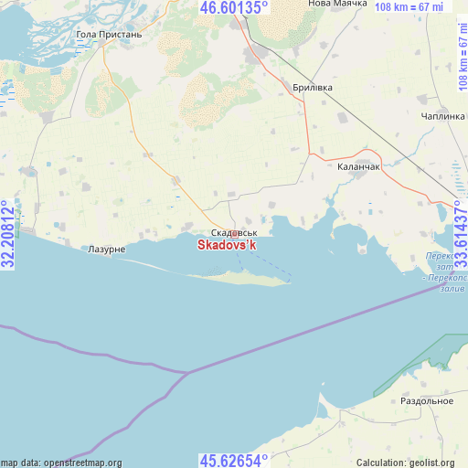
Skadovs’k GPS coordinates[2]
46° 6' 57.96" North, 32° 54' 40.464" East
| Map corner | latitude | longitude |
|---|---|---|
| Upper-left | 46.60135°, | 32.20812° |
| Center: | 46.1161°, | 32.91124° |
| Lower-right: | 45.62654°, | 33.61437° |
| Map W x H: | 108.4×108.4 km | = 67.4×67.4mi |
| max Lat: | 52.18903° ⇑69.1% North |
| Skadovs’k: | 46.1161° |
| min Lat: | ⇓30.9% South 44.39214° |
| min Long | Skadovs’k | max Long |
| 22.20555° | 32.91124° | 40.13222° |
| W 47%⇐ | ⇒53% E |
Elevation
Elevation of Skadovs’k is 6 m = 20 ft, and this is 149.8 m = 491 ft below average elevation for this country.
| Max E: |
886 m = 2907 ft | 98.6% |
| Avg. | 155.8 m = 511 ft | |
| Skadovs’k | 6 m = 20 ft | |
Min E: |
-3 m = -10 ft | 1.4% |
See also: Ukraine elevation on elevation.city.
Geographical zone
Skadovs’k is located in North temperate zone (between Tropic of Cancer and the Arctic Circle). Distance of this North polar circle is 2273.5 km =1412.7 mi to North.| Distance of | km | miles | from Skadovs’k |
|---|---|---|---|
| North Pole | 4879.4 | 3031.9 | to North |
| Arctic Circle | 2273.5 | 1412.7 | to North |
| Tropic Cancer | 2521.7 | 1566.9 | to South |
| Equator | 5127.6 | 3186.1 | to South |


Nearby cities:
15 places around Skadovs’k: (largest is in red/bold)
• Bekhtery
49.9 km =31 mi,  287°
287°
• Brylivka
38.8 km =24.1 mi,  27°
27°
• Chulakivka
50.7 km =31.5 mi,  301°
301°
• Dalekoye
52.4 km =32.6 mi,  165°
165°
• Kalanchak
33.1 km =20.6 mi,  61°
61°
• Krasne
11.1 km =6.9 mi,  278°
278°
• Lazurne
29.6 km =18.4 mi,  263°
263°
• Novofedorivka
46.1 km =28.6 mi, 277°
• Ogni
53.6 km =33.3 mi,  136°
136°
• Radens’k
48.1 km =29.9 mi,  1°
1°
• Slavnoye
50.6 km =31.4 mi,  150°
150°
• Slavyanskoye
53.6 km =33.3 mi, 143°
• Velyki Kopani
41.5 km =25.8 mi,  6°
6°
• Vynohradove
28.3 km =17.6 mi, 4°
• Zaliznyy Port
47.2 km =29.3 mi,  270°
270°
Sources, notices
• [Note1] Compared only with cities in Ukraine existing in our database
• [Src1] Map data: © OpenStreetMap contributors (CC-BY-SA)
• [Src2] Other city data from geonames.org with taken over terms of usage.
• [Src3] Geographical zone / Annual Mean Temperature by Robert A. Rohde @ Wikipedia
