Kalanchak geodata
Kalanchak (Kherson) is a seat of a second-order administrative division; located in Ukraine in Europe/Kiev (GMT+3) time zone. With population of 10,673 people, there are 340 cities with bigger population in this country. Compared to other cities in Ukraine, 68.2% of cities are located further ↑North; 50.3% of cities are located further →East and 96.8% of cities have higher elevation than Kalanchak. Note1


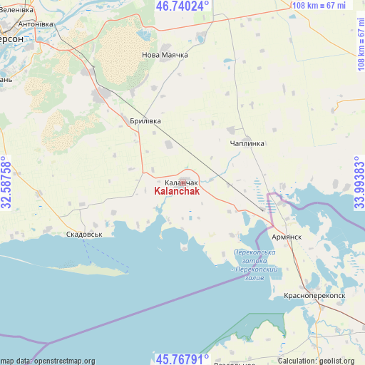
Kalanchak GPS coordinates[2]
46° 15' 22.428" North, 33° 17' 26.52" East
| Map corner | latitude | longitude |
|---|---|---|
| Upper-left | 46.74024°, | 32.58758° |
| Center: | 46.25623°, | 33.2907° |
| Lower-right: | 45.76791°, | 33.99383° |
| Map W x H: | 108.1×108.1 km | = 67.2×67.2mi |
| max Lat: | 52.18903° ⇑68.2% North |
| Kalanchak: | 46.25623° |
| min Lat: | ⇓31.8% South 44.39214° |
| min Long | Kalanchak | max Long |
| 22.20555° | 33.2907° | 40.13222° |
| W 49.7%⇐ | ⇒50.3% E |
Elevation
Elevation of Kalanchak is 9 m = 30 ft, and this is 146.8 m = 482 ft below average elevation for this country.
| Max E: |
886 m = 2907 ft | 96.8% |
| Avg. | 155.8 m = 511 ft | |
| Kalanchak | 9 m = 30 ft | |
Min E: |
-3 m = -10 ft | 3.2% |
See also: Ukraine elevation on elevation.city.
Geographical zone
Kalanchak is located in North temperate zone (between Tropic of Cancer and the Arctic Circle). Distance of this North polar circle is 2258 km =1403.1 mi to North.| Distance of | km | miles | from Kalanchak |
|---|---|---|---|
| North Pole | 4863.9 | 3022.3 | to North |
| Arctic Circle | 2258 | 1403.1 | to North |
| Tropic Cancer | 2537.3 | 1576.6 | to South |
| Equator | 5143.2 | 3195.8 | to South |


Nearby cities:
15 places around Kalanchak: (largest is in red/bold)
• Armyansk
35 km =21.7 mi,  117°
117°
• Brylivka
21.7 km =13.5 mi,  329°
329°
• Chaplynka
22.7 km =14.1 mi,  57°
57°
• Chornyanka
44.3 km =27.5 mi,  6°
6°
• Filatovka
42.7 km =26.5 mi, 116°
• Krasne
42.5 km =26.4 mi,  250°
250°
• Nova Mayachka
38.5 km =23.9 mi,  352°
352°
• Perekop
32.7 km =20.3 mi,  108°
108°
• Pochetnoye
46.7 km =29 mi,  128°
128°
• Radens’k
42.8 km =26.6 mi,  319°
319°
• Risovoye
40.1 km =24.9 mi, 129°
• Skadovs’k
33.1 km =20.6 mi,  241°
241°
• Suvorovo
35.8 km =22.2 mi, 121°
• Velyki Kopani
35.3 km =21.9 mi, 316°
• Vynohradove
29.8 km =18.5 mi,  295°
295°
Sources, notices
• [Note1] Compared only with cities in Ukraine existing in our database
• [Src1] Map data: © OpenStreetMap contributors (CC-BY-SA)
• [Src2] Other city data from geonames.org with taken over terms of usage.
• [Src3] Geographical zone / Annual Mean Temperature by Robert A. Rohde @ Wikipedia
