Rybakivka geodata
Rybakivka (Mykolaiv) is a populated place; located in Ukraine in Europe/Kiev (GMT+3) time zone. With population of 1,640 people, there are 1181 cities with bigger population in this country. Compared to other cities in Ukraine, 66.5% of cities are located further ↑North; 59.7% of cities are located further →East and 95.8% of cities have higher elevation than Rybakivka. Note1


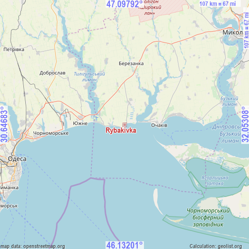
Rybakivka GPS coordinates[2]
46° 37' 1.632" North, 31° 20' 59.82" East
| Map corner | latitude | longitude |
|---|---|---|
| Upper-left | 47.09792°, | 30.64683° |
| Center: | 46.61712°, | 31.34995° |
| Lower-right: | 46.13201°, | 32.05308° |
| Map W x H: | 107.4×107.4 km | = 66.7×66.7mi |
| max Lat: | 52.18903° ⇑66.5% North |
| Rybakivka: | 46.61712° |
| min Lat: | ⇓33.5% South 44.39214° |
| min Long | Rybakivka | max Long |
| 22.20555° | 31.34995° | 40.13222° |
| W 40.3%⇐ | ⇒59.7% E |
Elevation
Elevation of Rybakivka is 10 m = 33 ft, and this is 145.8 m = 478 ft below average elevation for this country.
| Max E: |
886 m = 2907 ft | 95.8% |
| Avg. | 155.8 m = 511 ft | |
| Rybakivka | 10 m = 33 ft | |
Min E: |
-3 m = -10 ft | 4.2% |
See also: Ukraine elevation on elevation.city.
Geographical zone
Rybakivka is located in North temperate zone (between Tropic of Cancer and the Arctic Circle). Distance of this North polar circle is 2217.8 km =1378.1 mi to North.| Distance of | km | miles | from Rybakivka |
|---|---|---|---|
| North Pole | 4823.7 | 2997.3 | to North |
| Arctic Circle | 2217.8 | 1378.1 | to North |
| Tropic Cancer | 2577.4 | 1601.5 | to South |
| Equator | 5183.3 | 3220.8 | to South |


Nearby cities:
15 places around Rybakivka: (largest is in red/bold)
• Berezanka
26.3 km =16.3 mi,  6°
6°
• Dobroslav
38.1 km =23.7 mi,  304°
304°
• Fontanka
37.9 km =23.5 mi,  261°
261°
• Kobleve
12.1 km =7.5 mi, 296°
• Krasnosilka
44 km =27.3 mi,  270°
270°
• Kremidivka
45 km =28 mi,  286°
286°
• Kryzhanivka
42.9 km =26.7 mi, 261°
• Kurisove
49.2 km =30.6 mi,  322°
322°
• Ochakiv
15.3 km =9.5 mi,  91°
91°
• Odessa
49.7 km =30.9 mi,  251°
251°
• Parutyne
42.9 km =26.7 mi,  76°
76°
• Tayirove
60.6 km =37.7 mi,  242°
242°
• Usatove
53.6 km =33.3 mi, 259°
• Yuzhne
19 km =11.8 mi, 271°
• Геройское
42.9 km =26.7 mi,  106°
106°
Sources, notices
• [Note1] Compared only with cities in Ukraine existing in our database
• [Src1] Map data: © OpenStreetMap contributors (CC-BY-SA)
• [Src2] Other city data from geonames.org with taken over terms of usage.
• [Src3] Geographical zone / Annual Mean Temperature by Robert A. Rohde @ Wikipedia
