Геройское geodata
Геройское (Kherson) is a populated place; located in Ukraine in Europe/Kiev (GMT+3) time zone. With population of 639 people, there are 1557 cities with bigger population in this country. Compared to other cities in Ukraine, 67.1% of cities are located further ↑North; 57.7% of cities are located further →East and 99.9% of cities have higher elevation than Геройское. Note1


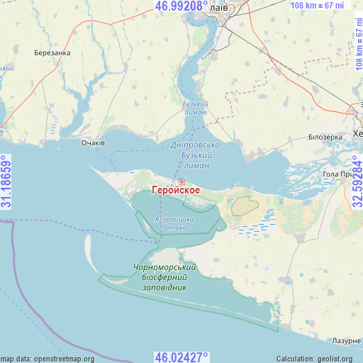
Геройское GPS coordinates[2]
46° 30' 37.188" North, 31° 53' 22.956" East
| Map corner | latitude | longitude |
|---|---|---|
| Upper-left | 46.99208°, | 31.18659° |
| Center: | 46.51033°, | 31.88971° |
| Lower-right: | 46.02427°, | 32.59284° |
| Map W x H: | 107.6×107.6 km | = 66.9×66.9mi |
| max Lat: | 52.18903° ⇑67.1% North |
| Геройское: | 46.51033° |
| min Lat: | ⇓32.9% South 44.39214° |
| min Long | Геройск� | max Long |
| 22.20555° | 31.88971° | 40.13222° |
| W 42.3%⇐ | ⇒57.7% E |
Elevation
Elevation of Геройское is 0 m = 0 ft, and this is 155.8 m = 511 ft below average elevation for this country.
| Max E: |
886 m = 2907 ft | 99.9% |
| Avg. | 155.8 m = 511 ft | |
| Геройское | 0 m = 0 ft | |
Min E: |
-3 m = -10 ft | 0.1% |
See also: Ukraine elevation on elevation.city.
Geographical zone
Геройское is located in North temperate zone (between Tropic of Cancer and the Arctic Circle). Distance of this North polar circle is 2229.7 km =1385.5 mi to North.| Distance of | km | miles | from Геройское |
|---|---|---|---|
| North Pole | 4835.6 | 3004.7 | to North |
| Arctic Circle | 2229.7 | 1385.5 | to North |
| Tropic Cancer | 2565.5 | 1594.1 | to South |
| Equator | 5171.5 | 3213.4 | to South |


Nearby cities:
15 places around Геройское: (largest is in red/bold)
• Bekhtery
42.4 km =26.3 mi,  133°
133°
• Berezanka
54 km =33.6 mi,  314°
314°
• Bilozerka
44.1 km =27.4 mi,  73°
73°
• Chornobayivka
54.7 km =34 mi, 68°
• Chulakivka
39.2 km =24.4 mi,  115°
115°
• Hola Prystan’
48.6 km =30.2 mi,  87°
87°
• Komyshany
49.3 km =30.6 mi, 73°
• Mykolayiv
51.3 km =31.9 mi,  9°
9°
• Novofedorivka
50 km =31.1 mi,  138°
138°
• Ochakiv
28.4 km =17.6 mi,  293°
293°
• Parutyne
21.7 km =13.5 mi,  1°
1°
• Rybakivka
42.9 km =26.7 mi, 286°
• Shevchenkove
45.9 km =28.5 mi,  31°
31°
• Stanislav
20.8 km =12.9 mi, 71°
• Zaliznyy Port
53.3 km =33.1 mi, 143°
Sources, notices
• [Note1] Compared only with cities in Ukraine existing in our database
• [Src1] Map data: © OpenStreetMap contributors (CC-BY-SA)
• [Src2] Other city data from geonames.org with taken over terms of usage.
• [Src3] Geographical zone / Annual Mean Temperature by Robert A. Rohde @ Wikipedia
