Kobleve geodata
Kobleve (Mykolaiv) is a populated place; located in Ukraine in Europe/Kiev (GMT+3) time zone. With population of 2,800 people, there are 990 cities with bigger population in this country. Compared to other cities in Ukraine, 66% of cities are located further ↑North; 60.2% of cities are located further →East and 85.7% of cities have higher elevation than Kobleve. Note1


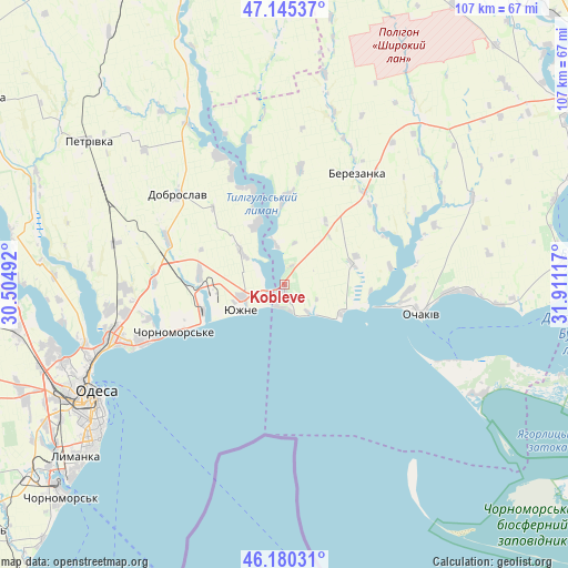
Kobleve GPS coordinates[2]
46° 39' 53.964" North, 31° 12' 28.944" East
| Map corner | latitude | longitude |
|---|---|---|
| Upper-left | 47.14537°, | 30.50492° |
| Center: | 46.66499°, | 31.20804° |
| Lower-right: | 46.18031°, | 31.91117° |
| Map W x H: | 107.3×107.3 km | = 66.7×66.7mi |
| max Lat: | 52.18903° ⇑66% North |
| Kobleve: | 46.66499° |
| min Lat: | ⇓34% South 44.39214° |
| min Long | Kobleve | max Long |
| 22.20555° | 31.20804° | 40.13222° |
| W 39.8%⇐ | ⇒60.2% E |
Elevation
Elevation of Kobleve is 28 m = 92 ft, and this is 127.8 m = 419 ft below average elevation for this country.
| Max E: |
886 m = 2907 ft | 85.7% |
| Avg. | 155.8 m = 511 ft | |
| Kobleve | 28 m = 92 ft | |
Min E: |
-3 m = -10 ft | 14.3% |
See also: Ukraine elevation on elevation.city.
Geographical zone
Kobleve is located in North temperate zone (between Tropic of Cancer and the Arctic Circle). Distance of this North polar circle is 2212.5 km =1374.8 mi to North.| Distance of | km | miles | from Kobleve |
|---|---|---|---|
| North Pole | 4818.4 | 2994 | to North |
| Arctic Circle | 2212.5 | 1374.8 | to North |
| Tropic Cancer | 2582.7 | 1604.8 | to South |
| Equator | 5188.7 | 3224.1 | to South |


Nearby cities:
15 places around Kobleve: (largest is in red/bold)
• Berezanka
25 km =15.5 mi,  33°
33°
• Dobroslav
26.3 km =16.3 mi,  308°
308°
• Fontanka
28.8 km =17.9 mi,  247°
247°
• Krasnosilka
33.5 km =20.8 mi,  261°
261°
• Kremidivka
33.2 km =20.6 mi,  283°
283°
• Kryzhanivka
33.6 km =20.9 mi, 249°
• Kurisove
38.8 km =24.1 mi,  330°
330°
• Ochakiv
26.7 km =16.6 mi,  102°
102°
• Odessa
41.9 km =26 mi,  240°
240°
• Parutyne
52.7 km =32.7 mi,  85°
85°
• Rybakivka
12.1 km =7.5 mi,  116°
116°
• Tayirove
54.4 km =33.8 mi,  231°
231°
• Usatove
44.4 km =27.6 mi, 250°
• Yuzhne
9.4 km =5.8 mi, 239°
• Геройское
54.9 km =34.1 mi,  108°
108°
Sources, notices
• [Note1] Compared only with cities in Ukraine existing in our database
• [Src1] Map data: © OpenStreetMap contributors (CC-BY-SA)
• [Src2] Other city data from geonames.org with taken over terms of usage.
• [Src3] Geographical zone / Annual Mean Temperature by Robert A. Rohde @ Wikipedia
