Fontanka geodata
Fontanka (Odesa) is a populated place; located in Ukraine in Europe/Kiev (GMT+3) time zone. With population of 6,027 people, there are 566 cities with bigger population in this country. Compared to other cities in Ukraine, 66.8% of cities are located further ↑North; 62.3% of cities are located further →East and 80.6% of cities have higher elevation than Fontanka. Note1


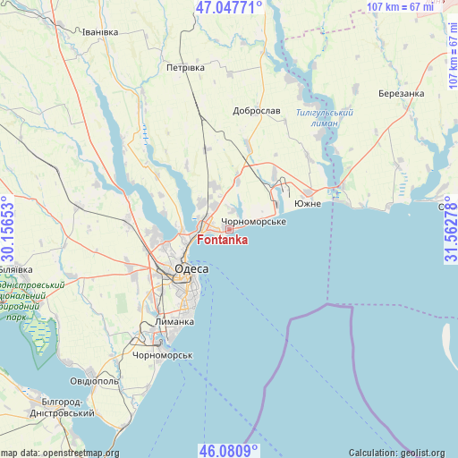
Fontanka GPS coordinates[2]
46° 33' 59.256" North, 30° 51' 34.74" East
| Map corner | latitude | longitude |
|---|---|---|
| Upper-left | 47.04771°, | 30.15653° |
| Center: | 46.56646°, | 30.85965° |
| Lower-right: | 46.0809°, | 31.56278° |
| Map W x H: | 107.5×107.5 km | = 66.8×66.8mi |
| max Lat: | 52.18903° ⇑66.8% North |
| Fontanka: | 46.56646° |
| min Lat: | ⇓33.2% South 44.39214° |
| min Long | Fontanka | max Long |
| 22.20555° | 30.85965° | 40.13222° |
| W 37.7%⇐ | ⇒62.3% E |
Elevation
Elevation of Fontanka is 41 m = 135 ft, and this is 114.8 m = 377 ft below average elevation for this country.
| Max E: |
886 m = 2907 ft | 80.6% |
| Avg. | 155.8 m = 511 ft | |
| Fontanka | 41 m = 135 ft | |
Min E: |
-3 m = -10 ft | 19.4% |
See also: Ukraine elevation on elevation.city.
Geographical zone
Fontanka is located in North temperate zone (between Tropic of Cancer and the Arctic Circle). Distance of this North polar circle is 2223.5 km =1381.6 mi to North.| Distance of | km | miles | from Fontanka |
|---|---|---|---|
| North Pole | 4829.4 | 3000.8 | to North |
| Arctic Circle | 2223.5 | 1381.6 | to North |
| Tropic Cancer | 2571.8 | 1598 | to South |
| Equator | 5177.7 | 3217.3 | to South |


Nearby cities:
15 places around Fontanka: (largest is in red/bold)
• Chornomors’k
33 km =20.5 mi,  208°
208°
• Dobroslav
28.1 km =17.5 mi,  12°
12°
• Kobleve
28.8 km =17.9 mi,  67°
67°
• Krasnosilka
9 km =5.6 mi,  313°
313°
• Kremidivka
19.4 km =12.1 mi,  342°
342°
• Kryzhanivka
5 km =3.1 mi,  263°
263°
• Kurisove
45.5 km =28.3 mi, 9°
• Odessa
13.9 km =8.6 mi,  224°
224°
• Oleksandrivka
31.5 km =19.6 mi, 213°
• Ovidiopol
47.6 km =29.6 mi, 222°
• Rybakivka
37.9 km =23.5 mi,  81°
81°
• Tayirove
27.8 km =17.3 mi, 215°
• Teplodar
41.4 km =25.7 mi, 260°
• Usatove
15.7 km =9.8 mi, 256°
• Yuzhne
19.5 km =12.1 mi, 71°
Sources, notices
• [Note1] Compared only with cities in Ukraine existing in our database
• [Src1] Map data: © OpenStreetMap contributors (CC-BY-SA)
• [Src2] Other city data from geonames.org with taken over terms of usage.
• [Src3] Geographical zone / Annual Mean Temperature by Robert A. Rohde @ Wikipedia
