Rakoshyno geodata
Rakoshyno (Transcarpathia) is a populated place; located in Ukraine in Europe/Uzhgorod (GMT+3) time zone. With population of 3,145 people, there are 901 cities with bigger population in this country. Compared to other cities in Ukraine, 54.6% of cities are located further ↓South; 99.3% of cities are located further →East and 56.9% of cities have higher elevation than Rakoshyno. Note1


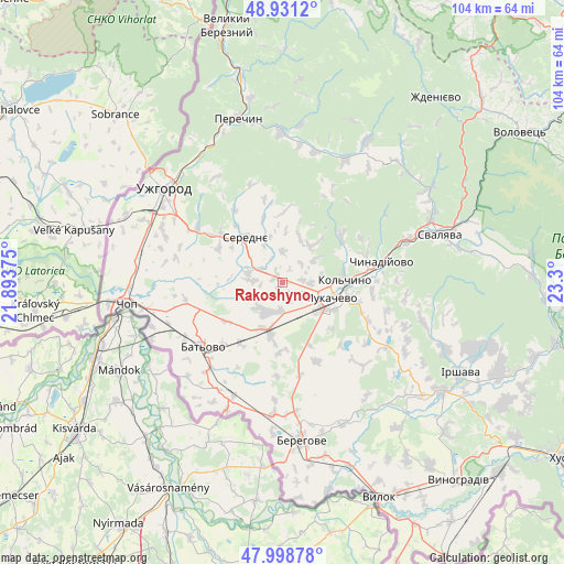
Rakoshyno GPS coordinates[2]
48° 28' 1.668" North, 22° 35' 48.732" East
| Map corner | latitude | longitude |
|---|---|---|
| Upper-left | 48.9312°, | 21.89375° |
| Center: | 48.46713°, | 22.59687° |
| Lower-right: | 47.99878°, | 23.3° |
| Map W x H: | 103.7×103.7 km | = 64.4×64.4mi |
| max Lat: | 52.18903° ⇑45.4% North |
| Rakoshyno: | 48.46713° |
| min Lat: | ⇓54.6% South 44.39214° |
| min Long | Rakoshyno | max Long |
| 22.20555° | 22.59687° | 40.13222° |
| W 0.7%⇐ | ⇒99.3% E |
Elevation
Elevation of Rakoshyno is 115 m = 377 ft, and this is 40.8 m = 134 ft below average elevation for this country.
| Max E: |
886 m = 2907 ft | 56.9% |
| Avg. | 155.8 m = 511 ft | |
| Rakoshyno | 115 m = 377 ft | |
Min E: |
-3 m = -10 ft | 43.1% |
See also: Ukraine elevation on elevation.city.
Geographical zone
Rakoshyno is located in North temperate zone (between Tropic of Cancer and the Arctic Circle). Distance of this North polar circle is 2012.1 km =1250.3 mi to North.| Distance of | km | miles | from Rakoshyno |
|---|---|---|---|
| North Pole | 4618 | 2869.5 | to North |
| Arctic Circle | 2012.1 | 1250.3 | to North |
| Tropic Cancer | 2783.1 | 1729.3 | to South |
| Equator | 5389 | 3348.6 | to South |


Nearby cities:
15 places around Rakoshyno: (largest is in red/bold)
• Batiovo
18.7 km =11.6 mi,  231°
231°
• Chop
29.1 km =18.1 mi,  262°
262°
• Chynadiyovo
16.7 km =10.4 mi,  84°
84°
• Kamianytsia
29.2 km =18.1 mi,  329°
329°
• Koson’
25.8 km =16 mi,  203°
203°
• Mukacheve
9.4 km =5.8 mi,  109°
109°
• Mynay
27.3 km =17 mi,  299°
299°
• Nevyts’ke
27.7 km =17.2 mi, 326°
• Nove Davydkovo
3.4 km =2.1 mi,  147°
147°
• Onokivtsi
28.3 km =17.6 mi,  318°
318°
• Poroshkovo
25.2 km =15.7 mi,  27°
27°
• Serednye
10.5 km =6.5 mi, 320°
• Strabychovo
9.2 km =5.7 mi,  205°
205°
• Uzhgorod
27.5 km =17.1 mi,  307°
307°
• Velyki Berehy
28.4 km =17.6 mi,  157°
157°
Sources, notices
• [Note1] Compared only with cities in Ukraine existing in our database
• [Src1] Map data: © OpenStreetMap contributors (CC-BY-SA)
• [Src2] Other city data from geonames.org with taken over terms of usage.
• [Src3] Geographical zone / Annual Mean Temperature by Robert A. Rohde @ Wikipedia
