Uzhgorod geodata
Uzhgorod (Transcarpathia) is a seat of a first-order administrative division; located in Ukraine in Europe/Uzhgorod (GMT+3) time zone. With population of 117,878 people, there are 39 cities with bigger population in this country. Compared to other cities in Ukraine, 58.1% of cities are located further ↓South; 99.8% of cities are located further →East and 55.4% of cities have higher elevation than Uzhgorod. Note1


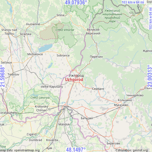
Uzhgorod GPS coordinates[2]
48° 37' 0.012" North, 22° 18' 0" East
| Map corner | latitude | longitude |
|---|---|---|
| Upper-left | 49.07936°, | 21.59688° |
| Center: | 48.61667°, | 22.3° |
| Lower-right: | 48.1497°, | 23.00313° |
| Map W x H: | 103.4×103.4 km | = 64.2×64.2mi |
| max Lat: | 52.18903° ⇑41.9% North |
| Uzhgorod: | 48.61667° |
| min Lat: | ⇓58.1% South 44.39214° |
| min Long | Uzhgorod | max Long |
| 22.20555° | 22.3° | 40.13222° |
| W 0.2%⇐ | ⇒99.8% E |
Elevation
Elevation of Uzhgorod is 119 m = 390 ft, and this is 36.8 m = 121 ft below average elevation for this country.
| Max E: |
886 m = 2907 ft | 55.4% |
| Avg. | 155.8 m = 511 ft | |
| Uzhgorod | 119 m = 390 ft | |
Min E: |
-3 m = -10 ft | 44.6% |
See also: Uzhgorod elevation on elevation.city.
Geographical zone
Uzhgorod is located in North temperate zone (between Tropic of Cancer and the Arctic Circle). Distance of this North polar circle is 1995.5 km =1239.9 mi to North.| Distance of | km | miles | from Uzhgorod |
|---|---|---|---|
| North Pole | 4601.4 | 2859.2 | to North |
| Arctic Circle | 1995.5 | 1239.9 | to North |
| Tropic Cancer | 2799.7 | 1739.7 | to South |
| Equator | 5405.7 | 3358.9 | to South |


Nearby cities:
15 places around Uzhgorod: (largest is in red/bold)
• Batiovo
29.3 km =18.2 mi,  165°
165°
• Chop
21.7 km =13.5 mi,  198°
198°
• Kamianytsia
11.1 km =6.9 mi,  39°
39°
• Mukacheve
36.5 km =22.7 mi,  122°
122°
• Mynay
3.6 km =2.2 mi,  210°
210°
• Nevyts’ke
9.1 km =5.7 mi,  45°
45°
• Nove Davydkovo
30.7 km =19.1 mi,  129°
129°
• Onokivtsi
5.5 km =3.4 mi,  34°
34°
• Perechyn
18.8 km =11.7 mi, 45°
• Poroshkovo
33.8 km =21 mi,  80°
80°
• Rakoshyno
27.5 km =17.1 mi, 127°
• Serednye
17.4 km =10.8 mi, 119°
• Storozhnytsya
5.1 km =3.2 mi,  254°
254°
• Strabychovo
30.7 km =19.1 mi,  144°
144°
• Velykyi Bereznyi
32.4 km =20.1 mi,  21°
21°
In other languages:
- In Spanish: Úzhgorod
- In France: Oujhorod
- In German: Uschgorod
- In Italian: Užhorod
- In Russian: Ужгород
- In Chinese: 乌日霍罗德
Sources, notices
• [Note1] Compared only with cities in Ukraine existing in our database
• [Src1] Map data: © OpenStreetMap contributors (CC-BY-SA)
• [Src2] Other city data from geonames.org with taken over terms of usage.
• [Src3] Geographical zone / Annual Mean Temperature by Robert A. Rohde @ Wikipedia
