Chynadiyovo geodata
Chynadiyovo (Transcarpathia) is a populated place; located in Ukraine in Europe/Uzhgorod (GMT+3) time zone. With population of 6,564 people, there are 535 cities with bigger population in this country. Compared to other cities in Ukraine, 54.9% of cities are located further ↓South; 98.7% of cities are located further →East and 52.6% of cities have lower elevation than Chynadiyovo. Note1


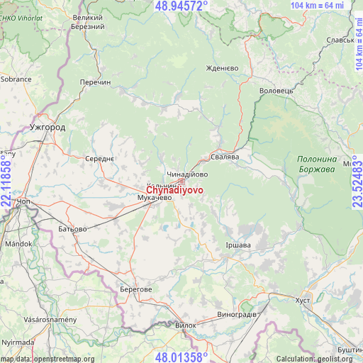
Chynadiyovo GPS coordinates[2]
48° 28' 54.444" North, 22° 49' 18.12" East
| Map corner | latitude | longitude |
|---|---|---|
| Upper-left | 48.94572°, | 22.11858° |
| Center: | 48.48179°, | 22.8217° |
| Lower-right: | 48.01358°, | 23.52483° |
| Map W x H: | 103.6×103.6 km | = 64.4×64.4mi |
| max Lat: | 52.18903° ⇑45.1% North |
| Chynadiyovo: | 48.48179° |
| min Lat: | ⇓54.9% South 44.39214° |
| min Long | Chynadiyovo | max Long |
| 22.20555° | 22.8217° | 40.13222° |
| W 1.3%⇐ | ⇒98.7% E |
Elevation
Elevation of Chynadiyovo is 144 m = 472 ft, and this is 11.8 m = 39 ft below average elevation for this country.
| Max E: |
886 m = 2907 ft | 47.4% |
| Avg. | 155.8 m = 511 ft | |
| Chynadiyovo | 144 m = 472 ft | |
Min E: |
-3 m = -10 ft | 52.6% |
See also: Ukraine elevation on elevation.city.
Geographical zone
Chynadiyovo is located in North temperate zone (between Tropic of Cancer and the Arctic Circle). Distance of this North polar circle is 2010.5 km =1249.3 mi to North.| Distance of | km | miles | from Chynadiyovo |
|---|---|---|---|
| North Pole | 4616.4 | 2868.5 | to North |
| Arctic Circle | 2010.5 | 1249.3 | to North |
| Tropic Cancer | 2784.8 | 1730.4 | to South |
| Equator | 5390.7 | 3349.6 | to South |


Nearby cities:
15 places around Chynadiyovo: (largest is in red/bold)
• Batiovo
33.9 km =21.1 mi,  246°
246°
• Berehove
33.4 km =20.8 mi,  203°
203°
• Bereznyky
29.6 km =18.4 mi,  83°
83°
• Bilky
29.5 km =18.3 mi,  128°
128°
• Irshava
24.4 km =15.2 mi,  138°
138°
• Kushnytsya
32.5 km =20.2 mi,  98°
98°
• Mukacheve
9 km =5.6 mi,  238°
238°
• Nelipyno
17.8 km =11.1 mi,  60°
60°
• Nove Davydkovo
15.4 km =9.6 mi, 253°
• Poroshkovo
21.3 km =13.2 mi,  346°
346°
• Rakoshyno
16.7 km =10.4 mi,  264°
264°
• Serednye
24.1 km =15 mi,  285°
285°
• Strabychovo
22.8 km =14.2 mi, 244°
• Svalyava
14.8 km =9.2 mi, 59°
• Velyki Berehy
28.3 km =17.6 mi,  191°
191°
Sources, notices
• [Note1] Compared only with cities in Ukraine existing in our database
• [Src1] Map data: © OpenStreetMap contributors (CC-BY-SA)
• [Src2] Other city data from geonames.org with taken over terms of usage.
• [Src3] Geographical zone / Annual Mean Temperature by Robert A. Rohde @ Wikipedia
