Kamianytsia geodata
Kamianytsia (Transcarpathia) is a populated place; located in Ukraine in Europe/Uzhgorod (GMT+3) time zone. With population of 1,886 people, there are 1130 cities with bigger population in this country. Compared to other cities in Ukraine, 60.3% of cities are located further ↓South; 99.7% of cities are located further →East and 59.2% of cities have lower elevation than Kamianytsia. Note1


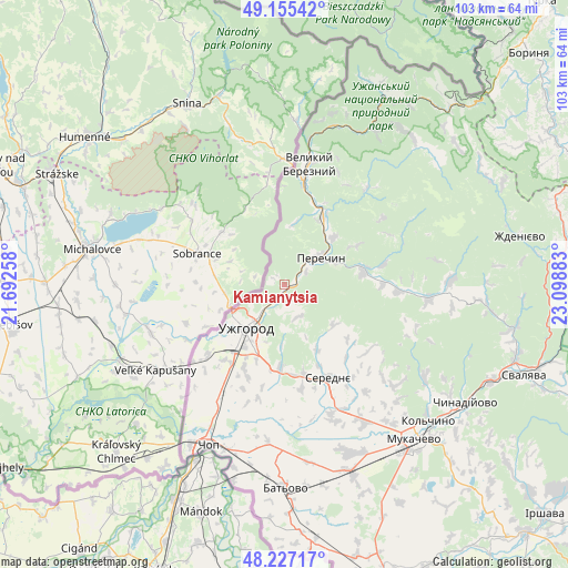
Kamianytsia GPS coordinates[2]
48° 41' 36.348" North, 22° 23' 44.52" East
| Map corner | latitude | longitude |
|---|---|---|
| Upper-left | 49.15542°, | 21.69258° |
| Center: | 48.69343°, | 22.3957° |
| Lower-right: | 48.22717°, | 23.09883° |
| Map W x H: | 103.2×103.2 km | = 64.1×64.1mi |
| max Lat: | 52.18903° ⇑39.7% North |
| Kamianytsia: | 48.69343° |
| min Lat: | ⇓60.3% South 44.39214° |
| min Long | Kamianytsia | max Long |
| 22.20555° | 22.3957° | 40.13222° |
| W 0.3%⇐ | ⇒99.7% E |
Elevation
Elevation of Kamianytsia is 166 m = 545 ft, and this is 10.2 m = 33 ft above average elevation for this country.
| Max E: |
886 m = 2907 ft | 40.8% |
| Kamianytsia | 166 m 545 ft | |
| Avg. | 155.8 m = 511 ft | |
Min E: |
-3 m = -10 ft | 59.2% |
See also: Ukraine elevation on elevation.city.
Geographical zone
Kamianytsia is located in North temperate zone (between Tropic of Cancer and the Arctic Circle). Distance of this North polar circle is 1987 km =1234.7 mi to North.| Distance of | km | miles | from Kamianytsia |
|---|---|---|---|
| North Pole | 4592.9 | 2853.9 | to North |
| Arctic Circle | 1987 | 1234.7 | to North |
| Tropic Cancer | 2808.3 | 1745 | to South |
| Equator | 5414.2 | 3364.2 | to South |


Nearby cities:
15 places around Kamianytsia: (largest is in red/bold)
• Batiovo
36.9 km =22.9 mi,  179°
179°
• Chop
32.3 km =20.1 mi,  205°
205°
• Mukacheve
36.9 km =22.9 mi,  140°
140°
• Mynay
14.6 km =9.1 mi,  217°
217°
• Nevyts’ke
2.2 km =1.4 mi,  194°
194°
• Nove Davydkovo
32.6 km =20.3 mi,  149°
149°
• Onokivtsi
5.6 km =3.5 mi, 224°
• Perechyn
7.9 km =4.9 mi,  53°
53°
• Poroshkovo
26.4 km =16.4 mi,  96°
96°
• Rakoshyno
29.2 km =18.1 mi, 149°
• Serednye
18.9 km =11.7 mi, 154°
• Storozhnytsya
15.6 km =9.7 mi,  230°
230°
• Strabychovo
35.2 km =21.9 mi,  162°
162°
• Uzhgorod
11.1 km =6.9 mi, 219°
• Velykyi Bereznyi
22.2 km =13.8 mi,  12°
12°
Sources, notices
• [Note1] Compared only with cities in Ukraine existing in our database
• [Src1] Map data: © OpenStreetMap contributors (CC-BY-SA)
• [Src2] Other city data from geonames.org with taken over terms of usage.
• [Src3] Geographical zone / Annual Mean Temperature by Robert A. Rohde @ Wikipedia
