Rakhiv geodata
Rakhiv (Transcarpathia) is a seat of a second-order administrative division; located in Ukraine in Europe/Uzhgorod (GMT+3) time zone. With population of 14,674 people, there are 260 cities with bigger population in this country. Compared to other cities in Ukraine, 55.5% of cities are located further ↑North; 91.5% of cities are located further →East and 97.3% of cities have lower elevation than Rakhiv. Note1


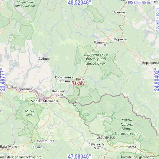
Rakhiv GPS coordinates[2]
48° 3' 9.36" North, 24° 12' 3.204" East
| Map corner | latitude | longitude |
|---|---|---|
| Upper-left | 48.52046°, | 23.49777° |
| Center: | 48.0526°, | 24.20089° |
| Lower-right: | 47.58045°, | 24.90402° |
| Map W x H: | 104.5×104.5 km | = 64.9×64.9mi |
| max Lat: | 52.18903° ⇑55.5% North |
| Rakhiv: | 48.0526° |
| min Lat: | ⇓44.5% South 44.39214° |
| min Long | Rakhiv | max Long |
| 22.20555° | 24.20089° | 40.13222° |
| W 8.5%⇐ | ⇒91.5% E |
Elevation
Elevation of Rakhiv is 439 m = 1440 ft, and this is 283.2 m = 929 ft above average elevation for this country.
| Max E: |
886 m = 2907 ft | 2.7% |
| Rakhiv | 439 m 1440 ft | |
| Avg. | 155.8 m = 511 ft | |
Min E: |
-3 m = -10 ft | 97.3% |
See also: Ukraine elevation on elevation.city.
Geographical zone
Rakhiv is located in North temperate zone (between Tropic of Cancer and the Arctic Circle). Distance of this North polar circle is 2058.2 km =1278.9 mi to North.| Distance of | km | miles | from Rakhiv |
|---|---|---|---|
| North Pole | 4664.1 | 2898.1 | to North |
| Arctic Circle | 2058.2 | 1278.9 | to North |
| Tropic Cancer | 2737 | 1700.7 | to South |
| Equator | 5342.9 | 3319.9 | to South |


Nearby cities:
15 places around Rakhiv: (largest is in red/bold)
• Bohdan
11.3 km =7 mi,  96°
96°
• Dubove
26.7 km =16.6 mi,  299°
299°
• Kalyny
26.2 km =16.3 mi,  291°
291°
• Krivopol’ye
40 km =24.9 mi,  66°
66°
• Kvasy
12.3 km =7.6 mi,  28°
28°
• Lazeshchyna
29 km =18 mi, 34°
• Lazi
2.9 km =1.8 mi,  57°
57°
• Lopukhiv
39 km =24.2 mi,  333°
333°
• Neresnytsya
33.1 km =20.6 mi,  282°
282°
• Palyanytsya
37.4 km =23.2 mi, 28°
• Serednye Vodyane
23 km =14.3 mi,  249°
249°
• Solotvyno
27.3 km =17 mi,  244°
244°
• Vorokhta
37.4 km =23.2 mi,  46°
46°
• Yablunytsya
36.2 km =22.5 mi,  35°
35°
• Yasinya
27.9 km =17.3 mi, 25°
Sources, notices
• [Note1] Compared only with cities in Ukraine existing in our database
• [Src1] Map data: © OpenStreetMap contributors (CC-BY-SA)
• [Src2] Other city data from geonames.org with taken over terms of usage.
• [Src3] Geographical zone / Annual Mean Temperature by Robert A. Rohde @ Wikipedia
