Dubove geodata
Dubove (Transcarpathia) is a populated place; located in Ukraine in Europe/Uzhgorod (GMT+3) time zone. With population of 8,902 people, there are 405 cities with bigger population in this country. Compared to other cities in Ukraine, 52.8% of cities are located further ↑North; 93.4% of cities are located further →East and 96% of cities have lower elevation than Dubove. Note1


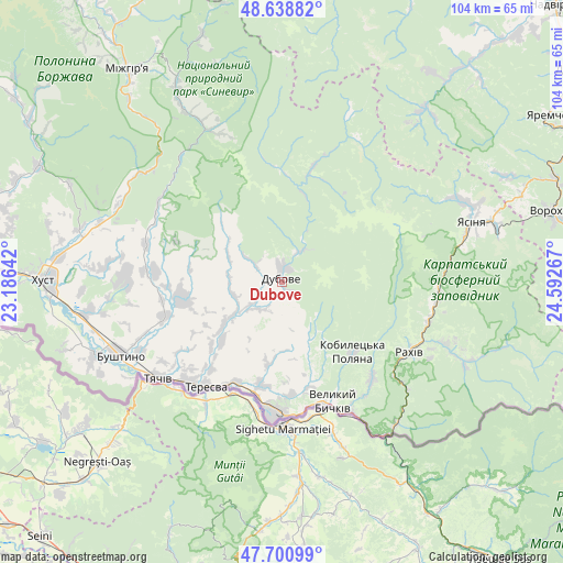
Dubove GPS coordinates[2]
48° 10' 19.38" North, 23° 53' 22.344" East
| Map corner | latitude | longitude |
|---|---|---|
| Upper-left | 48.63882°, | 23.18642° |
| Center: | 48.17205°, | 23.88954° |
| Lower-right: | 47.70099°, | 24.59267° |
| Map W x H: | 104.3×104.3 km | = 64.8×64.8mi |
| max Lat: | 52.18903° ⇑52.8% North |
| Dubove: | 48.17205° |
| min Lat: | ⇓47.2% South 44.39214° |
| min Long | Dubove | max Long |
| 22.20555° | 23.88954° | 40.13222° |
| W 6.6%⇐ | ⇒93.4% E |
Elevation
Elevation of Dubove is 383 m = 1257 ft, and this is 227.2 m = 745 ft above average elevation for this country.
| Max E: |
886 m = 2907 ft | 4% |
| Dubove | 383 m 1257 ft | |
| Avg. | 155.8 m = 511 ft | |
Min E: |
-3 m = -10 ft | 96% |
See also: Ukraine elevation on elevation.city.
Geographical zone
Dubove is located in North temperate zone (between Tropic of Cancer and the Arctic Circle). Distance of this North polar circle is 2044.9 km =1270.6 mi to North.| Distance of | km | miles | from Dubove |
|---|---|---|---|
| North Pole | 4650.8 | 2889.9 | to North |
| Arctic Circle | 2044.9 | 1270.6 | to North |
| Tropic Cancer | 2750.3 | 1709 | to South |
| Equator | 5356.2 | 3328.2 | to South |


Nearby cities:
15 places around Dubove: (largest is in red/bold)
• Berezovo
34.4 km =21.4 mi,  296°
296°
• Bushtyno
32.8 km =20.4 mi,  245°
245°
• Drahovo
26.2 km =16.3 mi,  285°
285°
• Kalyny
3.7 km =2.3 mi,  198°
198°
• Kolochava
31.9 km =19.8 mi,  333°
333°
• Kopashnovo
30.5 km =19 mi,  280°
280°
• Kvasy
29.1 km =18.1 mi,  94°
94°
• Lazi
28.1 km =17.5 mi,  114°
114°
• Lopukhiv
22.2 km =13.8 mi,  14°
14°
• Neresnytsya
11 km =6.8 mi,  236°
236°
• Nyzhnye Selyshche
32.9 km =20.4 mi, 275°
• Rakhiv
26.7 km =16.6 mi,  119°
119°
• Serednye Vodyane
21.2 km =13.2 mi,  175°
175°
• Solotvyno
25.2 km =15.7 mi, 183°
• Tyachiv
29.6 km =18.4 mi,  233°
233°
Sources, notices
• [Note1] Compared only with cities in Ukraine existing in our database
• [Src1] Map data: © OpenStreetMap contributors (CC-BY-SA)
• [Src2] Other city data from geonames.org with taken over terms of usage.
• [Src3] Geographical zone / Annual Mean Temperature by Robert A. Rohde @ Wikipedia
