Kalyny geodata
Kalyny (Transcarpathia) is a populated place; located in Ukraine in Europe/Uzhgorod (GMT+3) time zone. With population of 5,627 people, there are 596 cities with bigger population in this country. Compared to other cities in Ukraine, 53.7% of cities are located further ↑North; 93.5% of cities are located further →East and 94.5% of cities have lower elevation than Kalyny. Note1


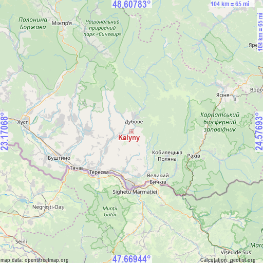
Kalyny GPS coordinates[2]
48° 8' 26.808" North, 23° 52' 25.68" East
| Map corner | latitude | longitude |
|---|---|---|
| Upper-left | 48.60783°, | 23.17068° |
| Center: | 48.14078°, | 23.8738° |
| Lower-right: | 47.66944°, | 24.57693° |
| Map W x H: | 104.3×104.3 km | = 64.8×64.8mi |
| max Lat: | 52.18903° ⇑53.7% North |
| Kalyny: | 48.14078° |
| min Lat: | ⇓46.3% South 44.39214° |
| min Long | Kalyny | max Long |
| 22.20555° | 23.8738° | 40.13222° |
| W 6.5%⇐ | ⇒93.5% E |
Elevation
Elevation of Kalyny is 353 m = 1158 ft, and this is 197.2 m = 647 ft above average elevation for this country.
| Max E: |
886 m = 2907 ft | 5.5% |
| Kalyny | 353 m 1158 ft | |
| Avg. | 155.8 m = 511 ft | |
Min E: |
-3 m = -10 ft | 94.5% |
See also: Ukraine elevation on elevation.city.
Geographical zone
Kalyny is located in North temperate zone (between Tropic of Cancer and the Arctic Circle). Distance of this North polar circle is 2048.4 km =1272.8 mi to North.| Distance of | km | miles | from Kalyny |
|---|---|---|---|
| North Pole | 4654.3 | 2892 | to North |
| Arctic Circle | 2048.4 | 1272.8 | to North |
| Tropic Cancer | 2746.8 | 1706.8 | to South |
| Equator | 5352.8 | 3326.1 | to South |


Nearby cities:
15 places around Kalyny: (largest is in red/bold)
• Bushtyno
30.5 km =19 mi,  250°
250°
• Drahovo
26.3 km =16.3 mi,  293°
293°
• Dubove
3.7 km =2.3 mi,  18°
18°
• Kolochava
34.6 km =21.5 mi,  337°
337°
• Kopashnovo
30.2 km =18.8 mi, 286°
• Kvasy
30.1 km =18.7 mi,  88°
88°
• Lazi
27.9 km =17.3 mi,  107°
107°
• Lopukhiv
25.8 km =16 mi,  14°
14°
• Neresnytsya
8.4 km =5.2 mi, 252°
• Nyzhnye Selyshche
32.3 km =20.1 mi,  281°
281°
• Rakhiv
26.2 km =16.3 mi, 111°
• Serednye Vodyane
17.9 km =11.1 mi,  171°
171°
• Solotvyno
21.7 km =13.5 mi,  180°
180°
• Tyachiv
26.7 km =16.6 mi,  237°
237°
• Vyshkovo
35.1 km =21.8 mi, 253°
Sources, notices
• [Note1] Compared only with cities in Ukraine existing in our database
• [Src1] Map data: © OpenStreetMap contributors (CC-BY-SA)
• [Src2] Other city data from geonames.org with taken over terms of usage.
• [Src3] Geographical zone / Annual Mean Temperature by Robert A. Rohde @ Wikipedia
