Ostroh geodata
Ostroh (Rivne) is a seat of a second-order administrative division; located in Ukraine in Europe/Kiev (GMT+3) time zone. With population of 14,251 people, there are 266 cities with bigger population in this country. Compared to other cities in Ukraine, 88.4% of cities are located further ↓South; 79.2% of cities are located further →East and 73.7% of cities have lower elevation than Ostroh. Note1


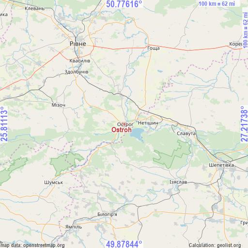
Ostroh GPS coordinates[2]
50° 19' 45.912" North, 26° 30' 51.3" East
| Map corner | latitude | longitude |
|---|---|---|
| Upper-left | 50.77616°, | 25.81113° |
| Center: | 50.32942°, | 26.51425° |
| Lower-right: | 49.87844°, | 27.21738° |
| Map W x H: | 99.8×99.8 km | = 62×62mi |
| max Lat: | 52.18903° ⇑11.6% North |
| Ostroh: | 50.32942° |
| min Lat: | ⇓88.4% South 44.39214° |
| min Long | Ostroh | max Long |
| 22.20555° | 26.51425° | 40.13222° |
| W 20.8%⇐ | ⇒79.2% E |
Elevation
Elevation of Ostroh is 219 m = 719 ft, and this is 63.2 m = 207 ft above average elevation for this country.
| Max E: |
886 m = 2907 ft | 26.3% |
| Ostroh | 219 m 719 ft | |
| Avg. | 155.8 m = 511 ft | |
Min E: |
-3 m = -10 ft | 73.7% |
See also: Ukraine elevation on elevation.city.
Geographical zone
Ostroh is located in North temperate zone (between Tropic of Cancer and the Arctic Circle). Distance of this North polar circle is 1805.1 km =1121.6 mi to North.| Distance of | km | miles | from Ostroh |
|---|---|---|---|
| North Pole | 4411 | 2740.9 | to North |
| Arctic Circle | 1805.1 | 1121.6 | to North |
| Tropic Cancer | 2990.2 | 1858 | to South |
| Equator | 5596.1 | 3477.3 | to South |


Nearby cities:
15 places around Ostroh: (largest is in red/bold)
• Horodyshche
36.1 km =22.4 mi,  343°
343°
• Hoshcha
32.2 km =20 mi,  20°
20°
• Izyaslav
32 km =19.9 mi,  136°
136°
• Kolodenka
31.8 km =19.8 mi,  333°
333°
• Lyakhovtsy
36.8 km =22.9 mi,  189°
189°
• Mizoch
27 km =16.8 mi,  286°
286°
• Netishyn
9.1 km =5.7 mi,  82°
82°
• Rivne
38.4 km =23.9 mi, 328°
• Shepetivka
42.2 km =26.2 mi,  112°
112°
• Shumsk
36.7 km =22.8 mi,  230°
230°
• Slavuta
25.1 km =15.6 mi,  97°
97°
• Tynne
38.2 km =23.7 mi,  322°
322°
• Velyki Mezhyrichi
43.9 km =27.3 mi,  34°
34°
• Zdolbuniv
28.7 km =17.8 mi, 317°
• Zdovbytsya
26.8 km =16.7 mi,  313°
313°
Sources, notices
• [Note1] Compared only with cities in Ukraine existing in our database
• [Src1] Map data: © OpenStreetMap contributors (CC-BY-SA)
• [Src2] Other city data from geonames.org with taken over terms of usage.
• [Src3] Geographical zone / Annual Mean Temperature by Robert A. Rohde @ Wikipedia
