Velyki Mezhyrichi geodata
Velyki Mezhyrichi (Rivne) is a populated place; located in Ukraine in Europe/Kiev (GMT+3) time zone. With population of 2,192 people, there are 1077 cities with bigger population in this country. Compared to other cities in Ukraine, 93.1% of cities are located further ↓South; 78.1% of cities are located further →East and 69.2% of cities have lower elevation than Velyki Mezhyrichi. Note1


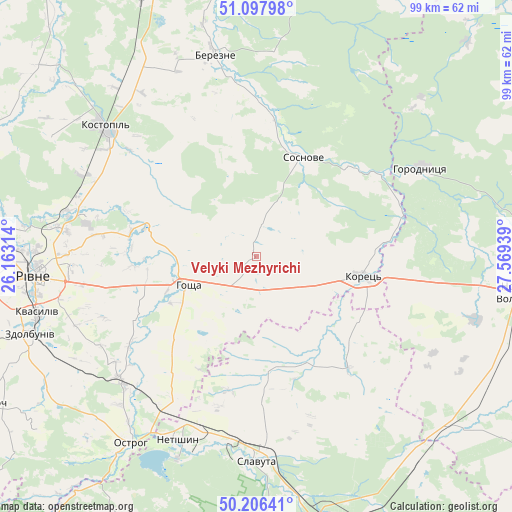
Velyki Mezhyrichi GPS coordinates[2]
50° 39' 15.516" North, 26° 51' 58.536" East
| Map corner | latitude | longitude |
|---|---|---|
| Upper-left | 51.09798°, | 26.16314° |
| Center: | 50.65431°, | 26.86626° |
| Lower-right: | 50.20641°, | 27.56939° |
| Map W x H: | 99.1×99.1 km | = 61.6×61.6mi |
| max Lat: | 52.18903° ⇑6.9% North |
| Velyki Mezhyrichi: | 50.65431° |
| min Lat: | ⇓93.1% South 44.39214° |
| min Long | Velyki Mezhyric | max Long |
| 22.20555° | 26.86626° | 40.13222° |
| W 21.9%⇐ | ⇒78.1% E |
Elevation
Elevation of Velyki Mezhyrichi is 202 m = 663 ft, and this is 46.2 m = 152 ft above average elevation for this country.
| Max E: |
886 m = 2907 ft | 30.8% |
| Velyki Mezhyrichi | 202 m 663 ft | |
| Avg. | 155.8 m = 511 ft | |
Min E: |
-3 m = -10 ft | 69.2% |
See also: Ukraine elevation on elevation.city.
Geographical zone
Velyki Mezhyrichi is located in North temperate zone (between Tropic of Cancer and the Arctic Circle). Distance of this North polar circle is 1768.9 km =1099.1 mi to North.| Distance of | km | miles | from Velyki Mezhyrichi |
|---|---|---|---|
| North Pole | 4374.8 | 2718.4 | to North |
| Arctic Circle | 1768.9 | 1099.1 | to North |
| Tropic Cancer | 3026.3 | 1880.5 | to South |
| Equator | 5632.2 | 3499.7 | to South |


Nearby cities:
15 places around Velyki Mezhyrichi: (largest is in red/bold)
• Berezne
39.4 km =24.5 mi,  348°
348°
• Horodnytsya
36 km =22.4 mi,  61°
61°
• Horodyshche
35.3 km =21.9 mi,  267°
267°
• Hoshcha
14.8 km =9.2 mi,  246°
246°
• Hubkiv
23.1 km =14.4 mi,  33°
33°
• Kolodenka
39.6 km =24.6 mi,  258°
258°
• Koloniya Zastav’ye
21.5 km =13.4 mi, 33°
• Korets
21.2 km =13.2 mi,  101°
101°
• Kostopil’
38.3 km =23.8 mi,  310°
310°
• Netishyn
38.4 km =23.9 mi,  204°
204°
• Ostroh
43.9 km =27.3 mi,  214°
214°
• Rivne
45.2 km =28.1 mi, 265°
• Slavuta
39.2 km =24.4 mi,  180°
180°
• Zdolbuniv
46.5 km =28.9 mi, 251°
• Zdovbytsya
47.5 km =29.5 mi, 248°
Sources, notices
• [Note1] Compared only with cities in Ukraine existing in our database
• [Src1] Map data: © OpenStreetMap contributors (CC-BY-SA)
• [Src2] Other city data from geonames.org with taken over terms of usage.
• [Src3] Geographical zone / Annual Mean Temperature by Robert A. Rohde @ Wikipedia
