Orlinoye geodata
Orlinoye (Sevastopol City) is a seat of a third-order administrative division; located in Ukraine in Europe/Simferopol (GMT+3) time zone. With population of 2,106 people, there are 1085 cities with bigger population in this country. Compared to other cities in Ukraine, 99.5% of cities are located further ↑North; 57% of cities are located further ←West and 85.8% of cities have lower elevation than Orlinoye. Note1
Administrative division(s):
- Level 1: Sevastopol City
- Level 2: Balaklava District
- Level 3: Orlinovskiy munitsipal'niy okrug


Orlinoye GPS coordinates[2]
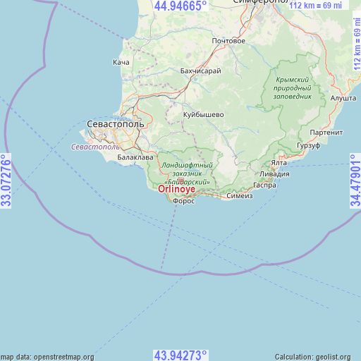
44° 26' 48.66" North, 33° 46' 33.168" East
| Map corner | latitude | longitude |
|---|---|---|
| Upper-left | 44.94665°, | 33.07276° |
| Center: | 44.44685°, | 33.77588° |
| Lower-right: | 43.94273°, | 34.47901° |
| Map W x H: | 111.6×111.6 km | = 69.3×69.3mi |
| max Lat: | 52.18903° ⇑99.5% North |
| Orlinoye: | 44.44685° |
| min Lat: | ⇓0.5% South 44.39214° |
| min Long | Orlinoye | max Long |
| 22.20555° | 33.77588° | 40.13222° |
| W 57%⇐ | ⇒43% E |
Elevation
Elevation of Orlinoye is 280 m = 919 ft, and this is 124.2 m = 407 ft above average elevation for this country.
| Max E: |
886 m = 2907 ft | 14.2% |
| Orlinoye | 280 m 919 ft | |
| Avg. | 155.8 m = 511 ft | |
Min E: |
-3 m = -10 ft | 85.8% |
See also: Ukraine elevation on elevation.city.
Geographical zone
Orlinoye is located in North temperate zone (between Tropic of Cancer and the Arctic Circle). Distance of this Northern Tropic circle is 2336.1 km =1451.6 mi to South.| Distance of | km | miles | from Orlinoye |
|---|---|---|---|
| North Pole | 5065 | 3147.2 | to North |
| Arctic Circle | 2459.1 | 1528 | to North |
| Tropic Cancer | 2336.1 | 1451.6 | to South |
| Equator | 4942 | 3070.8 | to South |


Nearby cities:
15 places around Orlinoye: (largest is in red/bold)
• Balaklava
15.7 km =9.8 mi,  297°
297°
• Foros
6.2 km =3.9 mi,  171°
171°
• Goluboy Zaliv
17.2 km =10.7 mi,  103°
103°
• Goncharnoye
6.4 km =4 mi,  289°
289°
• Katsiveli
16.6 km =10.3 mi,  110°
110°
• Khmel’nitskoye
14.6 km =9.1 mi,  318°
318°
• Peredovoye
8.1 km =5 mi,  31°
31°
• Pervomayskoye
16.1 km =10 mi,  309°
309°
• Rodnikovoye
6.3 km =3.9 mi,  72°
72°
• Rodnoye
12.3 km =7.6 mi,  346°
346°
• Shirokoye
3.7 km =2.3 mi, 350°
• Shturmovoye
18.1 km =11.2 mi, 317°
• Ternovka
14.8 km =9.2 mi, 352°
• Tylovoye
3.5 km =2.2 mi,  259°
259°
• Zolotaya Balka (1 otd.)
17.3 km =10.7 mi, 303°
Sources, notices
• [Note1] Compared only with cities in Ukraine existing in our database
• [Src1] Map data: © OpenStreetMap contributors (CC-BY-SA)
• [Src2] Other city data from geonames.org with taken over terms of usage.
• [Src3] Geographical zone / Annual Mean Temperature by Robert A. Rohde @ Wikipedia
