Ternovka geodata
Ternovka (Sevastopol City) is a seat of a third-order administrative division; located in Ukraine in Europe/Simferopol (GMT+3) time zone. With population of 1,843 people, there are 1141 cities with bigger population in this country. Compared to other cities in Ukraine, 98.2% of cities are located further ↑North; 56.5% of cities are located further ←West and 66.5% of cities have lower elevation than Ternovka. Note1
Administrative division(s):
- Level 1: Sevastopol City
- Level 2: Balaklava District
- Level 3: Ternovskiy munitsipal'niy okrug


Ternovka GPS coordinates[2]
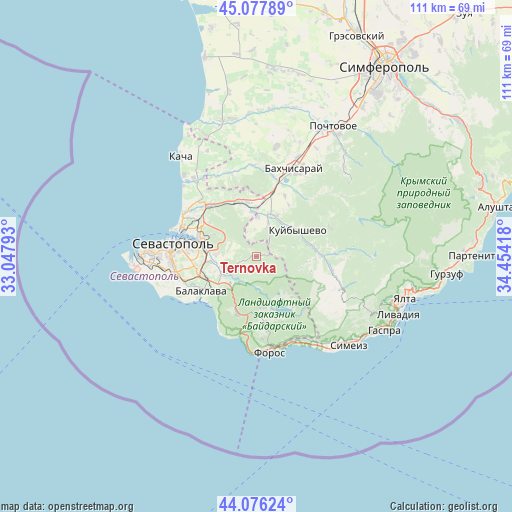
44° 34' 45.192" North, 33° 45' 3.78" East
| Map corner | latitude | longitude |
|---|---|---|
| Upper-left | 45.07789°, | 33.04793° |
| Center: | 44.57922°, | 33.75105° |
| Lower-right: | 44.07624°, | 34.45418° |
| Map W x H: | 111.4×111.4 km | = 69.2×69.2mi |
| max Lat: | 52.18903° ⇑98.2% North |
| Ternovka: | 44.57922° |
| min Lat: | ⇓1.8% South 44.39214° |
| min Long | Ternovka | max Long |
| 22.20555° | 33.75105° | 40.13222° |
| W 56.5%⇐ | ⇒43.5% E |
Elevation
Elevation of Ternovka is 192 m = 630 ft, and this is 36.2 m = 119 ft above average elevation for this country.
| Max E: |
886 m = 2907 ft | 33.5% |
| Ternovka | 192 m 630 ft | |
| Avg. | 155.8 m = 511 ft | |
Min E: |
-3 m = -10 ft | 66.5% |
See also: Ukraine elevation on elevation.city.
Geographical zone
Ternovka is located in North temperate zone (between Tropic of Cancer and the Arctic Circle). Distance of this Northern Tropic circle is 2350.8 km =1460.7 mi to South.| Distance of | km | miles | from Ternovka |
|---|---|---|---|
| North Pole | 5050.3 | 3138.1 | to North |
| Arctic Circle | 2444.4 | 1518.9 | to North |
| Tropic Cancer | 2350.8 | 1460.7 | to South |
| Equator | 4956.7 | 3079.9 | to South |


Nearby cities:
15 places around Ternovka: (largest is in red/bold)
• Frontovoye
9.9 km =6.2 mi,  354°
354°
• Golubinka
13.1 km =8.1 mi,  82°
82°
• Inkerman
11.8 km =7.3 mi,  289°
289°
• Khmel’nitskoye
8.6 km =5.3 mi,  243°
243°
• Kholmovka
8.8 km =5.5 mi,  1°
1°
• Krasnyi Mak
7.4 km =4.6 mi,  18°
18°
• Kuibyshevo
10.9 km =6.8 mi,  59°
59°
• Peredovoye
9.9 km =6.2 mi,  141°
141°
• Pervomayskoye
11.4 km =7.1 mi,  246°
246°
• Rodnoye
3 km =1.9 mi,  198°
198°
• Sakharnaya Golovka
8.5 km =5.3 mi,  273°
273°
• Shirokoye
11.2 km =7 mi,  172°
172°
• Shturmovoye
10.3 km =6.4 mi,  262°
262°
• Tankovoye
9.9 km =6.2 mi,  27°
27°
• Verkhnesadovoye
12.8 km =8 mi,  342°
342°
Sources, notices
• [Note1] Compared only with cities in Ukraine existing in our database
• [Src1] Map data: © OpenStreetMap contributors (CC-BY-SA)
• [Src2] Other city data from geonames.org with taken over terms of usage.
• [Src3] Geographical zone / Annual Mean Temperature by Robert A. Rohde @ Wikipedia
