Nekrasovka geodata
Nekrasovka (Republic of Crimea) is a seat of a third-order administrative division; located in Ukraine in Europe/Simferopol (GMT+3) time zone. With population of 1,044 people, there are 1356 cities with bigger population in this country. Compared to other cities in Ukraine, 79% of cities are located further ↑North; 80.4% of cities are located further ←West and 95.8% of cities have higher elevation than Nekrasovka. Note1
Administrative division(s):
- Level 1: Republic of Crimea
- Level 2: Sovietskyi Raion
- Level 3: Nekrasovskoye sel'skoye poselenye


Nekrasovka GPS coordinates[2]
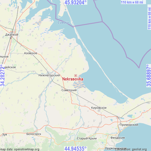
45° 26' 27.06" North, 34° 59' 9.024" East
| Map corner | latitude | longitude |
|---|---|---|
| Upper-left | 45.93204°, | 34.28272° |
| Center: | 45.44085°, | 34.98584° |
| Lower-right: | 44.94535°, | 35.68897° |
| Map W x H: | 109.7×109.7 km | = 68.2×68.2mi |
| max Lat: | 52.18903° ⇑79% North |
| Nekrasovka: | 45.44085° |
| min Lat: | ⇓21% South 44.39214° |
| min Long | Nekrasovka | max Long |
| 22.20555° | 34.98584° | 40.13222° |
| W 80.4%⇐ | ⇒19.6% E |
Elevation
Elevation of Nekrasovka is 10 m = 33 ft, and this is 145.8 m = 478 ft below average elevation for this country.
| Max E: |
886 m = 2907 ft | 95.8% |
| Avg. | 155.8 m = 511 ft | |
| Nekrasovka | 10 m = 33 ft | |
Min E: |
-3 m = -10 ft | 4.2% |
See also: Ukraine elevation on elevation.city.
Geographical zone
Nekrasovka is located in North temperate zone (between Tropic of Cancer and the Arctic Circle). Distance of this North polar circle is 2348.6 km =1459.4 mi to North.| Distance of | km | miles | from Nekrasovka |
|---|---|---|---|
| North Pole | 4954.5 | 3078.6 | to North |
| Arctic Circle | 2348.6 | 1459.4 | to North |
| Tropic Cancer | 2446.6 | 1520.2 | to South |
| Equator | 5052.5 | 3139.5 | to South |


Nearby cities:
15 places around Nekrasovka: (largest is in red/bold)
• Akimovka
15.3 km =9.5 mi,  304°
304°
• Chernozemnoye
13.5 km =8.4 mi,  254°
254°
• Dmitrovka
7.5 km =4.7 mi,  49°
49°
• Izobil’noye
14.7 km =9.1 mi,  347°
347°
• Krasnoflotskoye
14.2 km =8.8 mi,  192°
192°
• Listvennoye
14.4 km =8.9 mi,  288°
288°
• Novoivanovka
14.7 km =9.1 mi,  277°
277°
• Okhotskoye
10.8 km =6.7 mi, 297°
• Oktyabr’skoye
7.5 km =4.7 mi,  232°
232°
• Razdol’noye
13.5 km =8.4 mi, 229°
• Sovetskiy
11.9 km =7.4 mi,  203°
203°
• Urozhaynoye
13.3 km =8.3 mi,  150°
150°
• Uvarovka
15.5 km =9.6 mi,  274°
274°
• Varvarovka
14.8 km =9.2 mi,  207°
207°
• Yemelyanovka
12.4 km =7.7 mi,  325°
325°
Sources, notices
• [Note1] Compared only with cities in Ukraine existing in our database
• [Src1] Map data: © OpenStreetMap contributors (CC-BY-SA)
• [Src2] Other city data from geonames.org with taken over terms of usage.
• [Src3] Geographical zone / Annual Mean Temperature by Robert A. Rohde @ Wikipedia
