Izobil’noye geodata
Izobil’noye (Republic of Crimea) is a seat of a third-order administrative division; located in Ukraine in Europe/Simferopol (GMT+3) time zone. With population of 991 people, there are 1389 cities with bigger population in this country. Compared to other cities in Ukraine, 75.8% of cities are located further ↑North; 79.6% of cities are located further ←West and 95.3% of cities have higher elevation than Izobil’noye. Note1
Administrative division(s):
- Level 1: Republic of Crimea
- Level 2: Nizhnegorskiy rayon
- Level 3: Izobil'nenskoye sel'skoye poselenye


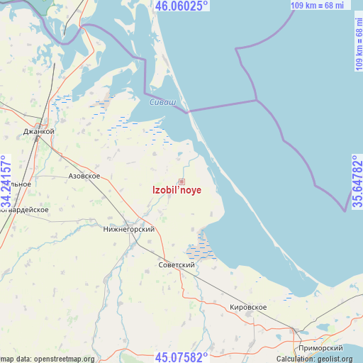
Izobil’noye GPS coordinates[2]
45° 34' 12.684" North, 34° 56' 40.884" East
| Map corner | latitude | longitude |
|---|---|---|
| Upper-left | 46.06025°, | 34.24157° |
| Center: | 45.57019°, | 34.94469° |
| Lower-right: | 45.07582°, | 35.64782° |
| Map W x H: | 109.5×109.5 km | = 68×68mi |
| max Lat: | 52.18903° ⇑75.8% North |
| Izobil’noye: | 45.57019° |
| min Lat: | ⇓24.2% South 44.39214° |
| min Long | Izobil’noye | max Long |
| 22.20555° | 34.94469° | 40.13222° |
| W 79.6%⇐ | ⇒20.4% E |
Elevation
Elevation of Izobil’noye is 11 m = 36 ft, and this is 144.8 m = 475 ft below average elevation for this country.
| Max E: |
886 m = 2907 ft | 95.3% |
| Avg. | 155.8 m = 511 ft | |
| Izobil’noye | 11 m = 36 ft | |
Min E: |
-3 m = -10 ft | 4.7% |
See also: Ukraine elevation on elevation.city.
Geographical zone
Izobil’noye is located in North temperate zone (between Tropic of Cancer and the Arctic Circle). Distance of this North polar circle is 2334.2 km =1450.4 mi to North.| Distance of | km | miles | from Izobil’noye |
|---|---|---|---|
| North Pole | 4940.1 | 3069.6 | to North |
| Arctic Circle | 2334.2 | 1450.4 | to North |
| Tropic Cancer | 2461 | 1529.2 | to South |
| Equator | 5066.9 | 3148.4 | to South |


Nearby cities:
15 places around Izobil’noye: (largest is in red/bold)
• Akimovka
10.9 km =6.8 mi,  239°
239°
• Chernozemnoye
20.5 km =12.7 mi,  208°
208°
• Chkalovo
9.4 km =5.8 mi,  294°
294°
• Dmitrovka
13.1 km =8.1 mi,  137°
137°
• Listvennoye
14.4 km =8.9 mi,  226°
226°
• Nekrasovka
14.7 km =9.1 mi,  167°
167°
• Novoivanovka
16.9 km =10.5 mi,  222°
222°
• Okhotskoye
11.3 km =7 mi, 213°
• Oktyabr’skoye
19.2 km =11.9 mi,  188°
188°
• Pshenichnoye
11.9 km =7.4 mi,  315°
315°
• Semennoye
18.9 km =11.7 mi, 228°
• Uvarovka
18 km =11.2 mi, 222°
• Yemelyanovka
5.6 km =3.5 mi, 222°
• Zelyonoye
20.2 km =12.6 mi, 234°
• Zorkino
18.4 km =11.4 mi,  262°
262°
Sources, notices
• [Note1] Compared only with cities in Ukraine existing in our database
• [Src1] Map data: © OpenStreetMap contributors (CC-BY-SA)
• [Src2] Other city data from geonames.org with taken over terms of usage.
• [Src3] Geographical zone / Annual Mean Temperature by Robert A. Rohde @ Wikipedia
