Varvarovka geodata
Varvarovka (Republic of Crimea) is a populated place; located in Ukraine in Europe/Simferopol (GMT+3) time zone. With population of 595 people, there are 1586 cities with bigger population in this country. Compared to other cities in Ukraine, 82% of cities are located further ↑North; 79% of cities are located further ←West and 87.6% of cities have higher elevation than Varvarovka. Note1
Administrative division(s):
- Level 1: Republic of Crimea
- Level 2: Sovietskyi Raion
- Level 3: Krasnoflotskoye sel'skoye poselenye


Varvarovka GPS coordinates[2]
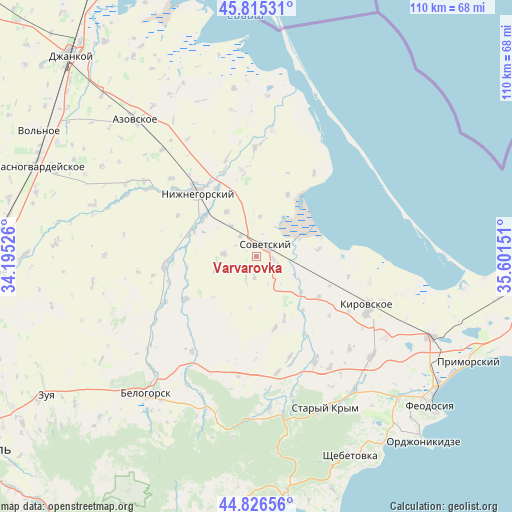
45° 19' 23.124" North, 34° 53' 54.168" East
| Map corner | latitude | longitude |
|---|---|---|
| Upper-left | 45.81531°, | 34.19526° |
| Center: | 45.32309°, | 34.89838° |
| Lower-right: | 44.82656°, | 35.60151° |
| Map W x H: | 109.9×109.9 km | = 68.3×68.3mi |
| max Lat: | 52.18903° ⇑82% North |
| Varvarovka: | 45.32309° |
| min Lat: | ⇓18% South 44.39214° |
| min Long | Varvarovka | max Long |
| 22.20555° | 34.89838° | 40.13222° |
| W 79%⇐ | ⇒21% E |
Elevation
Elevation of Varvarovka is 23 m = 75 ft, and this is 132.8 m = 436 ft below average elevation for this country.
| Max E: |
886 m = 2907 ft | 87.6% |
| Avg. | 155.8 m = 511 ft | |
| Varvarovka | 23 m = 75 ft | |
Min E: |
-3 m = -10 ft | 12.4% |
See also: Ukraine elevation on elevation.city.
Geographical zone
Varvarovka is located in North temperate zone (between Tropic of Cancer and the Arctic Circle). Distance of this North polar circle is 2361.7 km =1467.5 mi to North.| Distance of | km | miles | from Varvarovka |
|---|---|---|---|
| North Pole | 4967.6 | 3086.7 | to North |
| Arctic Circle | 2361.7 | 1467.5 | to North |
| Tropic Cancer | 2433.5 | 1512.1 | to South |
| Equator | 5039.5 | 3131.4 | to South |


Nearby cities:
15 places around Varvarovka: (largest is in red/bold)
• Chapayevka
4.7 km =2.9 mi,  183°
183°
• Chernozemnoye
11.3 km =7 mi,  327°
327°
• Frunze
15 km =9.3 mi,  260°
260°
• Ivanovka
15 km =9.3 mi,  292°
292°
• Krasnoflotskoye
3.9 km =2.4 mi,  102°
102°
• Nekrasovka
14.8 km =9.2 mi,  27°
27°
• Novy Mir
5.2 km =3.2 mi,  204°
204°
• Oktyabr’skoye
8.5 km =5.3 mi,  6°
6°
• Pchel’niki
9.5 km =5.9 mi,  250°
250°
• Pushkino
14.6 km =9.1 mi,  155°
155°
• Razdol’noye
5.5 km =3.4 mi,  321°
321°
• Sovetskiy
3 km =1.9 mi,  43°
43°
• Urozhaynoye
13.4 km =8.3 mi,  83°
83°
• Zavetnoye
7 km =4.3 mi,  273°
273°
• Zhelyabovka
13.8 km =8.6 mi,  307°
307°
Sources, notices
• [Note1] Compared only with cities in Ukraine existing in our database
• [Src1] Map data: © OpenStreetMap contributors (CC-BY-SA)
• [Src2] Other city data from geonames.org with taken over terms of usage.
• [Src3] Geographical zone / Annual Mean Temperature by Robert A. Rohde @ Wikipedia
