Mykolaiv geodata
Mykolaiv (Lviv) is a seat of a second-order administrative division; located in Ukraine in Europe/Kiev (GMT+3) time zone. With population of 14,251 people, there are 266 cities with bigger population in this country. Compared to other cities in Ukraine, 74.8% of cities are located further ↓South; 92.6% of cities are located further →East and 87.5% of cities have lower elevation than Mykolaiv. Note1


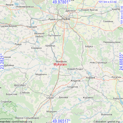
Mykolaiv GPS coordinates[2]
49° 31' 25.392" North, 23° 59' 6.792" East
| Map corner | latitude | longitude |
|---|---|---|
| Upper-left | 49.97801°, | 23.2821° |
| Center: | 49.52372°, | 23.98522° |
| Lower-right: | 49.06517°, | 24.68835° |
| Map W x H: | 101.5×101.5 km | = 63.1×63.1mi |
| max Lat: | 52.18903° ⇑25.2% North |
| Mykolaiv: | 49.52372° |
| min Lat: | ⇓74.8% South 44.39214° |
| min Long | Mykolaiv | max Long |
| 22.20555° | 23.98522° | 40.13222° |
| W 7.4%⇐ | ⇒92.6% E |
Elevation
Elevation of Mykolaiv is 290 m = 951 ft, and this is 134.2 m = 440 ft above average elevation for this country.
| Max E: |
886 m = 2907 ft | 12.5% |
| Mykolaiv | 290 m 951 ft | |
| Avg. | 155.8 m = 511 ft | |
Min E: |
-3 m = -10 ft | 87.5% |
See also: Ukraine elevation on elevation.city.
Geographical zone
Mykolaiv is located in North temperate zone (between Tropic of Cancer and the Arctic Circle). Distance of this North polar circle is 1894.7 km =1177.3 mi to North.| Distance of | km | miles | from Mykolaiv |
|---|---|---|---|
| North Pole | 4500.5 | 2796.5 | to North |
| Arctic Circle | 1894.7 | 1177.3 | to North |
| Tropic Cancer | 2900.6 | 1802.3 | to South |
| Equator | 5506.5 | 3421.6 | to South |


Nearby cities:
15 places around Mykolaiv: (largest is in red/bold)
• Bibrka
25.5 km =15.8 mi,  59°
59°
• Demnya
5.6 km =3.5 mi,  329°
329°
• Horbachi
9.6 km =6 mi, 325°
• Khodoriv
26.3 km =16.3 mi,  118°
118°
• Komarno
23.6 km =14.7 mi,  299°
299°
• Medenychi
19.9 km =12.4 mi,  238°
238°
• Navaria
25.4 km =15.8 mi,  350°
350°
• Pustomyty
21.9 km =13.6 mi, 346°
• Rozdil
8.9 km =5.5 mi,  141°
141°
• Rozvadiv
2.8 km =1.7 mi,  216°
216°
• Shchyrets
16.3 km =10.1 mi, 330°
• Shpyl’chyna
26.4 km =16.4 mi,  53°
53°
• Solonka
25.9 km =16.1 mi,  3°
3°
• Staroye Selo
25.4 km =15.8 mi,  35°
35°
• Zhydachiv
19.2 km =11.9 mi, 143°
Sources, notices
• [Note1] Compared only with cities in Ukraine existing in our database
• [Src1] Map data: © OpenStreetMap contributors (CC-BY-SA)
• [Src2] Other city data from geonames.org with taken over terms of usage.
• [Src3] Geographical zone / Annual Mean Temperature by Robert A. Rohde @ Wikipedia
