Khodoriv geodata
Khodoriv (Lviv) is a populated place; located in Ukraine in Europe/Kiev (GMT+3) time zone. With population of 10,172 people, there are 354 cities with bigger population in this country. Compared to other cities in Ukraine, 72.9% of cities are located further ↓South; 90.7% of cities are located further →East and 83.3% of cities have lower elevation than Khodoriv. Note1


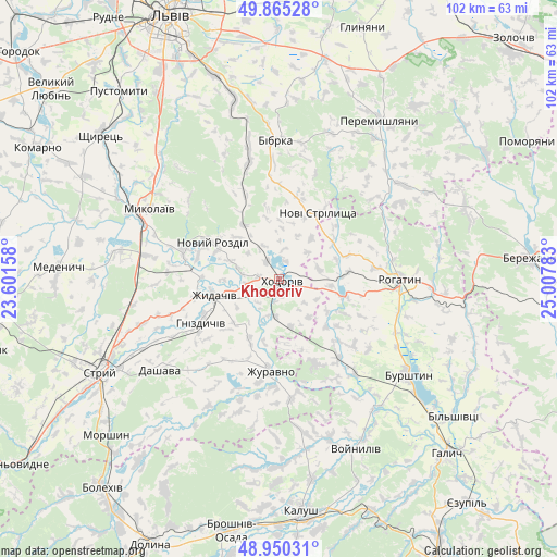
Khodoriv GPS coordinates[2]
49° 24' 35.748" North, 24° 18' 16.92" East
| Map corner | latitude | longitude |
|---|---|---|
| Upper-left | 49.86528°, | 23.60158° |
| Center: | 49.40993°, | 24.3047° |
| Lower-right: | 48.95031°, | 25.00783° |
| Map W x H: | 101.7×101.7 km | = 63.2×63.2mi |
| max Lat: | 52.18903° ⇑27.1% North |
| Khodoriv: | 49.40993° |
| min Lat: | ⇓72.9% South 44.39214° |
| min Long | Khodoriv | max Long |
| 22.20555° | 24.3047° | 40.13222° |
| W 9.3%⇐ | ⇒90.7% E |
Elevation
Elevation of Khodoriv is 265 m = 869 ft, and this is 109.2 m = 358 ft above average elevation for this country.
| Max E: |
886 m = 2907 ft | 16.7% |
| Khodoriv | 265 m 869 ft | |
| Avg. | 155.8 m = 511 ft | |
Min E: |
-3 m = -10 ft | 83.3% |
See also: Ukraine elevation on elevation.city.
Geographical zone
Khodoriv is located in North temperate zone (between Tropic of Cancer and the Arctic Circle). Distance of this North polar circle is 1907.3 km =1185.1 mi to North.| Distance of | km | miles | from Khodoriv |
|---|---|---|---|
| North Pole | 4513.2 | 2804.4 | to North |
| Arctic Circle | 1907.3 | 1185.1 | to North |
| Tropic Cancer | 2888 | 1794.5 | to South |
| Equator | 5493.9 | 3413.8 | to South |


Nearby cities:
15 places around Khodoriv: (largest is in red/bold)
• Bibrka
25.7 km =16 mi,  357°
357°
• Burshtyn
28.8 km =17.9 mi,  125°
125°
• Chesniki
30.6 km =19 mi,  94°
94°
• Demnya
31.3 km =19.4 mi,  304°
304°
• Horbachi
35.2 km =21.9 mi,  305°
305°
• Mykolaiv
26.3 km =16.3 mi, 298°
• Novi Strilyscha
13.8 km =8.6 mi,  31°
31°
• Peremyshlyany
33.8 km =21 mi, 32°
• Rohatyn
22 km =13.7 mi, 90°
• Rozdil
18.4 km =11.4 mi,  288°
288°
• Rozvadiv
26.9 km =16.7 mi, 292°
• Shpyl’chyna
28.3 km =17.6 mi, 356°
• Staroye Selo
34.4 km =21.4 mi,  346°
346°
• Svirzh
28.3 km =17.6 mi,  20°
20°
• Zhydachiv
12.1 km =7.5 mi,  256°
256°
Sources, notices
• [Note1] Compared only with cities in Ukraine existing in our database
• [Src1] Map data: © OpenStreetMap contributors (CC-BY-SA)
• [Src2] Other city data from geonames.org with taken over terms of usage.
• [Src3] Geographical zone / Annual Mean Temperature by Robert A. Rohde @ Wikipedia
