Demnya geodata
Demnya (Lviv) is a populated place; located in Ukraine in Europe/Kiev (GMT+3) time zone. With population of 1,602 people, there are 1192 cities with bigger population in this country. Compared to other cities in Ukraine, 75.8% of cities are located further ↓South; 92.9% of cities are located further →East and 81.7% of cities have lower elevation than Demnya. Note1


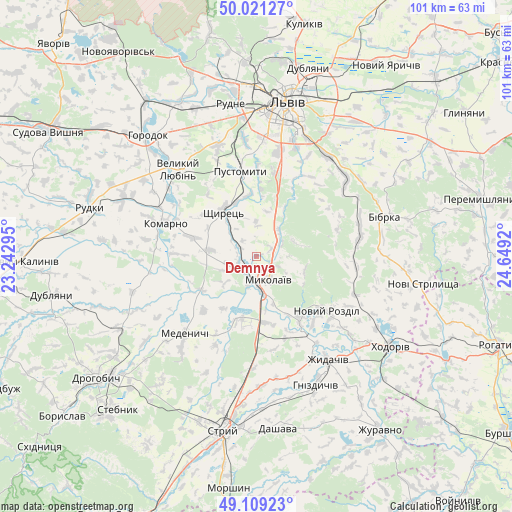
Demnya GPS coordinates[2]
49° 34' 2.568" North, 23° 56' 45.852" East
| Map corner | latitude | longitude |
|---|---|---|
| Upper-left | 50.02127°, | 23.24295° |
| Center: | 49.56738°, | 23.94607° |
| Lower-right: | 49.10923°, | 24.6492° |
| Map W x H: | 101.4×101.4 km | = 63×63mi |
| max Lat: | 52.18903° ⇑24.2% North |
| Demnya: | 49.56738° |
| min Lat: | ⇓75.8% South 44.39214° |
| min Long | Demnya | max Long |
| 22.20555° | 23.94607° | 40.13222° |
| W 7.1%⇐ | ⇒92.9% E |
Elevation
Elevation of Demnya is 257 m = 843 ft, and this is 101.2 m = 332 ft above average elevation for this country.
| Max E: |
886 m = 2907 ft | 18.3% |
| Demnya | 257 m 843 ft | |
| Avg. | 155.8 m = 511 ft | |
Min E: |
-3 m = -10 ft | 81.7% |
See also: Ukraine elevation on elevation.city.
Geographical zone
Demnya is located in North temperate zone (between Tropic of Cancer and the Arctic Circle). Distance of this North polar circle is 1889.8 km =1174.3 mi to North.| Distance of | km | miles | from Demnya |
|---|---|---|---|
| North Pole | 4495.7 | 2793.5 | to North |
| Arctic Circle | 1889.8 | 1174.3 | to North |
| Tropic Cancer | 2905.5 | 1805.4 | to South |
| Equator | 5511.4 | 3424.6 | to South |


Nearby cities:
15 places around Demnya: (largest is in red/bold)
• Bibrka
26 km =16.2 mi,  71°
71°
• Godovytsya
22.3 km =13.9 mi,  354°
354°
• Horbachi
4 km =2.5 mi,  318°
318°
• Komarno
19 km =11.8 mi,  290°
290°
• Medenychi
20.7 km =12.9 mi,  222°
222°
• Mykolaiv
5.6 km =3.5 mi,  149°
149°
• Navaria
20.3 km =12.6 mi,  356°
356°
• Obroshyne
24.7 km =15.3 mi, 346°
• Pustomyty
16.6 km =10.3 mi, 351°
• Rozdil
14.5 km =9 mi,  144°
144°
• Rozvadiv
7.2 km =4.5 mi,  170°
170°
• Shchyrets
10.6 km =6.6 mi,  330°
330°
• Solonka
21.5 km =13.4 mi,  12°
12°
• Staroye Selo
23.7 km =14.7 mi,  47°
47°
• Zhydachiv
24.8 km =15.4 mi, 145°
Sources, notices
• [Note1] Compared only with cities in Ukraine existing in our database
• [Src1] Map data: © OpenStreetMap contributors (CC-BY-SA)
• [Src2] Other city data from geonames.org with taken over terms of usage.
• [Src3] Geographical zone / Annual Mean Temperature by Robert A. Rohde @ Wikipedia
