Bibrka geodata
Bibrka (Lviv) is a populated place; located in Ukraine in Europe/Kiev (GMT+3) time zone. With population of 3,832 people, there are 784 cities with bigger population in this country. Compared to other cities in Ukraine, 76.7% of cities are located further ↓South; 90.9% of cities are located further →East and 90.6% of cities have lower elevation than Bibrka. Note1


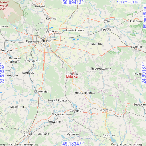
Bibrka GPS coordinates[2]
49° 38' 27.348" North, 24° 17' 19.464" East
| Map corner | latitude | longitude |
|---|---|---|
| Upper-left | 50.09413°, | 23.58562° |
| Center: | 49.64093°, | 24.28874° |
| Lower-right: | 49.18347°, | 24.99187° |
| Map W x H: | 101.3×101.3 km | = 62.9×62.9mi |
| max Lat: | 52.18903° ⇑23.3% North |
| Bibrka: | 49.64093° |
| min Lat: | ⇓76.7% South 44.39214° |
| min Long | Bibrka | max Long |
| 22.20555° | 24.28874° | 40.13222° |
| W 9.1%⇐ | ⇒90.9% E |
Elevation
Elevation of Bibrka is 312 m = 1024 ft, and this is 156.2 m = 512 ft above average elevation for this country.
| Max E: |
886 m = 2907 ft | 9.4% |
| Bibrka | 312 m 1024 ft | |
| Avg. | 155.8 m = 511 ft | |
Min E: |
-3 m = -10 ft | 90.6% |
See also: Ukraine elevation on elevation.city.
Geographical zone
Bibrka is located in North temperate zone (between Tropic of Cancer and the Arctic Circle). Distance of this North polar circle is 1881.6 km =1169.2 mi to North.| Distance of | km | miles | from Bibrka |
|---|---|---|---|
| North Pole | 4487.5 | 2788.4 | to North |
| Arctic Circle | 1881.6 | 1169.2 | to North |
| Tropic Cancer | 2913.6 | 1810.4 | to South |
| Equator | 5519.6 | 3429.7 | to South |


Nearby cities:
15 places around Bibrka: (largest is in red/bold)
• Demnya
26 km =16.2 mi,  251°
251°
• Dzvinogrud
10.6 km =6.6 mi,  344°
344°
• Horbachi
27.8 km =17.3 mi,  259°
259°
• Khodoriv
25.7 km =16 mi,  177°
177°
• Mykolaiv
25.5 km =15.8 mi,  239°
239°
• Novi Strilyscha
16.2 km =10.1 mi,  149°
149°
• Peremyshlyany
19.6 km =12.2 mi,  82°
82°
• Pustomyty
28.3 km =17.6 mi,  287°
287°
• Rozdil
25.8 km =16 mi,  219°
219°
• Rozvadiv
28.1 km =17.5 mi, 236°
• Shpyl’chyna
2.6 km =1.6 mi,  347°
347°
• Solonka
23.8 km =14.8 mi,  302°
302°
• Staroye Selo
10.5 km =6.5 mi,  317°
317°
• Svirzh
10.9 km =6.8 mi,  85°
85°
• Verkhnyaya Belka
19.5 km =12.1 mi,  3°
3°
Sources, notices
• [Note1] Compared only with cities in Ukraine existing in our database
• [Src1] Map data: © OpenStreetMap contributors (CC-BY-SA)
• [Src2] Other city data from geonames.org with taken over terms of usage.
• [Src3] Geographical zone / Annual Mean Temperature by Robert A. Rohde @ Wikipedia
