Rozdil geodata
Rozdil (Lviv) is a populated place; located in Ukraine in Europe/Kiev (GMT+3) time zone. With population of 2,892 people, there are 978 cities with bigger population in this country. Compared to other cities in Ukraine, 74.1% of cities are located further ↓South; 92.2% of cities are located further →East and 84.5% of cities have lower elevation than Rozdil. Note1


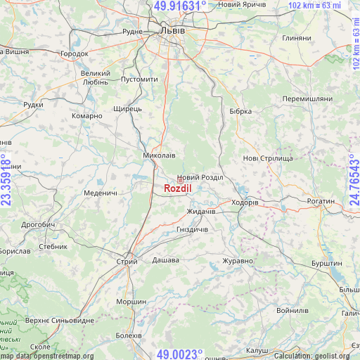
Rozdil GPS coordinates[2]
49° 27' 41.184" North, 24° 3' 44.28" East
| Map corner | latitude | longitude |
|---|---|---|
| Upper-left | 49.91631°, | 23.35918° |
| Center: | 49.46144°, | 24.0623° |
| Lower-right: | 49.0023°, | 24.76543° |
| Map W x H: | 101.6×101.6 km | = 63.1×63.1mi |
| max Lat: | 52.18903° ⇑25.9% North |
| Rozdil: | 49.46144° |
| min Lat: | ⇓74.1% South 44.39214° |
| min Long | Rozdil | max Long |
| 22.20555° | 24.0623° | 40.13222° |
| W 7.8%⇐ | ⇒92.2% E |
Elevation
Elevation of Rozdil is 271 m = 889 ft, and this is 115.2 m = 378 ft above average elevation for this country.
| Max E: |
886 m = 2907 ft | 15.5% |
| Rozdil | 271 m 889 ft | |
| Avg. | 155.8 m = 511 ft | |
Min E: |
-3 m = -10 ft | 84.5% |
See also: Ukraine elevation on elevation.city.
Geographical zone
Rozdil is located in North temperate zone (between Tropic of Cancer and the Arctic Circle). Distance of this North polar circle is 1901.6 km =1181.6 mi to North.| Distance of | km | miles | from Rozdil |
|---|---|---|---|
| North Pole | 4507.5 | 2800.8 | to North |
| Arctic Circle | 1901.6 | 1181.6 | to North |
| Tropic Cancer | 2893.7 | 1798.1 | to South |
| Equator | 5499.6 | 3417.3 | to South |


Nearby cities:
15 places around Rozdil: (largest is in red/bold)
• Bibrka
25.8 km =16 mi,  39°
39°
• Demnya
14.5 km =9 mi,  324°
324°
• Duliby
31.2 km =19.4 mi,  214°
214°
• Horbachi
18.5 km =11.5 mi, 323°
• Khodoriv
18.4 km =11.4 mi,  108°
108°
• Medenychi
22.8 km =14.2 mi,  261°
261°
• Mykolaiv
8.9 km =5.5 mi, 321°
• Novi Strilyscha
25.4 km =15.8 mi,  76°
76°
• Pustomyty
30.2 km =18.8 mi,  339°
339°
• Rozvadiv
8.6 km =5.3 mi,  302°
302°
• Shchyrets
25.1 km =15.6 mi,  327°
327°
• Shpyl’chyna
27.5 km =17.1 mi, 35°
• Staroye Selo
29.2 km =18.1 mi,  18°
18°
• Stryi
26.7 km =16.6 mi, 213°
• Zhydachiv
10.3 km =6.4 mi,  145°
145°
Sources, notices
• [Note1] Compared only with cities in Ukraine existing in our database
• [Src1] Map data: © OpenStreetMap contributors (CC-BY-SA)
• [Src2] Other city data from geonames.org with taken over terms of usage.
• [Src3] Geographical zone / Annual Mean Temperature by Robert A. Rohde @ Wikipedia
