Mlyniv geodata
Mlyniv (Rivne) is a seat of a second-order administrative division; located in Ukraine in Europe/Kiev (GMT+3) time zone. With population of 8,228 people, there are 430 cities with bigger population in this country. Compared to other cities in Ukraine, 91% of cities are located further ↓South; 83% of cities are located further →East and 67.5% of cities have lower elevation than Mlyniv. Note1


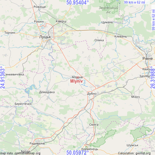
Mlyniv GPS coordinates[2]
50° 30' 32.4" North, 25° 37' 0.3" East
| Map corner | latitude | longitude |
|---|---|---|
| Upper-left | 50.95404°, | 24.91363° |
| Center: | 50.509°, | 25.61675° |
| Lower-right: | 50.05972°, | 26.31988° |
| Map W x H: | 99.4×99.4 km | = 61.8×61.8mi |
| max Lat: | 52.18903° ⇑9% North |
| Mlyniv: | 50.509° |
| min Lat: | ⇓91% South 44.39214° |
| min Long | Mlyniv | max Long |
| 22.20555° | 25.61675° | 40.13222° |
| W 17%⇐ | ⇒83% E |
Elevation
Elevation of Mlyniv is 196 m = 643 ft, and this is 40.2 m = 132 ft above average elevation for this country.
| Max E: |
886 m = 2907 ft | 32.5% |
| Mlyniv | 196 m 643 ft | |
| Avg. | 155.8 m = 511 ft | |
Min E: |
-3 m = -10 ft | 67.5% |
See also: Ukraine elevation on elevation.city.
Geographical zone
Mlyniv is located in North temperate zone (between Tropic of Cancer and the Arctic Circle). Distance of this North polar circle is 1785.1 km =1109.2 mi to North.| Distance of | km | miles | from Mlyniv |
|---|---|---|---|
| North Pole | 4391 | 2728.4 | to North |
| Arctic Circle | 1785.1 | 1109.2 | to North |
| Tropic Cancer | 3010.2 | 1870.5 | to South |
| Equator | 5616.1 | 3489.7 | to South |


Nearby cities:
15 places around Mlyniv: (largest is in red/bold)
• Berestechko
39.5 km =24.5 mi,  245°
245°
• Demydivka
21.8 km =13.5 mi, 245°
• Dubno
13.2 km =8.2 mi,  140°
140°
• Kivertsi
37.9 km =23.5 mi,  342°
342°
• Klevan
36.3 km =22.6 mi,  44°
44°
• Kremenets
46.5 km =28.9 mi,  170°
170°
• Lutsk
33.9 km =21.1 mi,  325°
325°
• Mizoch
39.6 km =24.6 mi,  107°
107°
• Olyka
27.1 km =16.8 mi,  30°
30°
• Rivne
45 km =28 mi,  73°
73°
• Smyga
31.8 km =19.8 mi,  160°
160°
• Tarakaniv
15.8 km =9.8 mi, 155°
• Tynne
41.4 km =25.7 mi,  75°
75°
• Zdolbuniv
44.3 km =27.5 mi,  88°
88°
• Zdovbytsya
44.2 km =27.5 mi, 91°
Sources, notices
• [Note1] Compared only with cities in Ukraine existing in our database
• [Src1] Map data: © OpenStreetMap contributors (CC-BY-SA)
• [Src2] Other city data from geonames.org with taken over terms of usage.
• [Src3] Geographical zone / Annual Mean Temperature by Robert A. Rohde @ Wikipedia
