Berestechko geodata
Berestechko (Volyn) is a populated place; located in Ukraine in Europe/Kiev (GMT+3) time zone. With population of 1,830 people, there are 1142 cities with bigger population in this country. Compared to other cities in Ukraine, 88.9% of cities are located further ↓South; 85.6% of cities are located further →East and 66.2% of cities have lower elevation than Berestechko. Note1


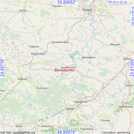
Berestechko GPS coordinates[2]
50° 21' 37.692" North, 25° 6' 38.556" East
| Map corner | latitude | longitude |
|---|---|---|
| Upper-left | 50.80692°, | 24.40759° |
| Center: | 50.36047°, | 25.11071° |
| Lower-right: | 49.90979°, | 25.81384° |
| Map W x H: | 99.8×99.7 km | = 62×62mi |
| max Lat: | 52.18903° ⇑11.1% North |
| Berestechko: | 50.36047° |
| min Lat: | ⇓88.9% South 44.39214° |
| min Long | Berestechko | max Long |
| 22.20555° | 25.11071° | 40.13222° |
| W 14.4%⇐ | ⇒85.6% E |
Elevation
Elevation of Berestechko is 190 m = 623 ft, and this is 34.2 m = 112 ft above average elevation for this country.
| Max E: |
886 m = 2907 ft | 33.8% |
| Berestechko | 190 m 623 ft | |
| Avg. | 155.8 m = 511 ft | |
Min E: |
-3 m = -10 ft | 66.2% |
See also: Ukraine elevation on elevation.city.
Geographical zone
Berestechko is located in North temperate zone (between Tropic of Cancer and the Arctic Circle). Distance of this North polar circle is 1801.6 km =1119.5 mi to North.| Distance of | km | miles | from Berestechko |
|---|---|---|---|
| North Pole | 4407.5 | 2738.7 | to North |
| Arctic Circle | 1801.6 | 1119.5 | to North |
| Tropic Cancer | 2993.6 | 1860.1 | to South |
| Equator | 5599.6 | 3479.4 | to South |


Nearby cities:
15 places around Berestechko: (largest is in red/bold)
• Brody
30.4 km =18.9 mi,  174°
174°
• Demydivka
17.7 km =11 mi,  64°
64°
• Dubno
44.7 km =27.8 mi,  81°
81°
• Horokhiv
29.3 km =18.2 mi,  302°
302°
• Kulykiv
21.4 km =13.3 mi,  256°
256°
• Lopatyn
24.3 km =15.1 mi,  230°
230°
• Lutsk
47.3 km =29.4 mi,  20°
20°
• Mlyniv
39.5 km =24.5 mi,  65°
65°
• Olesko
46.9 km =29.1 mi,  199°
199°
• Pidhirtsi
47 km =29.2 mi,  191°
191°
• Pidkamin’
48.4 km =30.1 mi,  162°
162°
• Radekhiv
34.3 km =21.3 mi, 255°
• Radyvyliv
27.6 km =17.1 mi, 158°
• Smyga
48.4 km =30.1 mi,  106°
106°
• Tarakaniv
42.4 km =26.3 mi,  87°
87°
Sources, notices
• [Note1] Compared only with cities in Ukraine existing in our database
• [Src1] Map data: © OpenStreetMap contributors (CC-BY-SA)
• [Src2] Other city data from geonames.org with taken over terms of usage.
• [Src3] Geographical zone / Annual Mean Temperature by Robert A. Rohde @ Wikipedia
