Smyga geodata
Smyga (Khmelnytskyi) is a populated place; located in Ukraine in Europe/Kiev (GMT+3) time zone. With population of 2,800 people, there are 990 cities with bigger population in this country. Compared to other cities in Ukraine, 87.1% of cities are located further ↓South; 82.1% of cities are located further →East and 74.7% of cities have lower elevation than Smyga. Note1


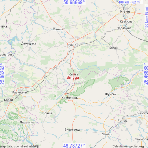
Smyga GPS coordinates[2]
50° 14' 20.76" North, 25° 45' 56.7" East
| Map corner | latitude | longitude |
|---|---|---|
| Upper-left | 50.68669°, | 25.06263° |
| Center: | 50.2391°, | 25.76575° |
| Lower-right: | 49.78727°, | 26.46888° |
| Map W x H: | 100×100 km | = 62.1×62.1mi |
| max Lat: | 52.18903° ⇑12.9% North |
| Smyga: | 50.2391° |
| min Lat: | ⇓87.1% South 44.39214° |
| min Long | Smyga | max Long |
| 22.20555° | 25.76575° | 40.13222° |
| W 17.9%⇐ | ⇒82.1% E |
Elevation
Elevation of Smyga is 225 m = 738 ft, and this is 69.2 m = 227 ft above average elevation for this country.
| Max E: |
886 m = 2907 ft | 25.3% |
| Smyga | 225 m 738 ft | |
| Avg. | 155.8 m = 511 ft | |
Min E: |
-3 m = -10 ft | 74.7% |
See also: Ukraine elevation on elevation.city.
Geographical zone
Smyga is located in North temperate zone (between Tropic of Cancer and the Arctic Circle). Distance of this North polar circle is 1815.1 km =1127.9 mi to North.| Distance of | km | miles | from Smyga |
|---|---|---|---|
| North Pole | 4421 | 2747.1 | to North |
| Arctic Circle | 1815.1 | 1127.9 | to North |
| Tropic Cancer | 2980.1 | 1851.7 | to South |
| Equator | 5586.1 | 3471 | to South |


Nearby cities:
15 places around Smyga: (largest is in red/bold)
• Berestechko
48.4 km =30.1 mi,  286°
286°
• Brody
47 km =29.2 mi,  249°
249°
• Demydivka
37 km =23 mi,  304°
304°
• Dubno
19.9 km =12.4 mi,  353°
353°
• Kremenets
16.1 km =10 mi,  190°
190°
• Lanivtsi
47.8 km =29.7 mi,  150°
150°
• Mizoch
32.6 km =20.3 mi,  56°
56°
• Mlyniv
31.8 km =19.8 mi,  340°
340°
• Pidkamin’
45.7 km =28.4 mi,  224°
224°
• Pochaiv
31.7 km =19.7 mi,  214°
214°
• Radyvyliv
38.3 km =23.8 mi, 251°
• Shumsk
28 km =17.4 mi,  117°
117°
• Tarakaniv
16.1 km =10 mi, 345°
• Zdolbuniv
46.1 km =28.6 mi,  47°
47°
• Zdovbytsya
44.2 km =27.5 mi, 49°
Sources, notices
• [Note1] Compared only with cities in Ukraine existing in our database
• [Src1] Map data: © OpenStreetMap contributors (CC-BY-SA)
• [Src2] Other city data from geonames.org with taken over terms of usage.
• [Src3] Geographical zone / Annual Mean Temperature by Robert A. Rohde @ Wikipedia
