Korets geodata
Korets (Rivne) is a seat of a second-order administrative division; located in Ukraine in Europe/Kiev (GMT+3) time zone. With population of 8,446 people, there are 421 cities with bigger population in this country. Compared to other cities in Ukraine, 92.6% of cities are located further ↓South; 77.7% of cities are located further →East and 72.2% of cities have lower elevation than Korets. Note1


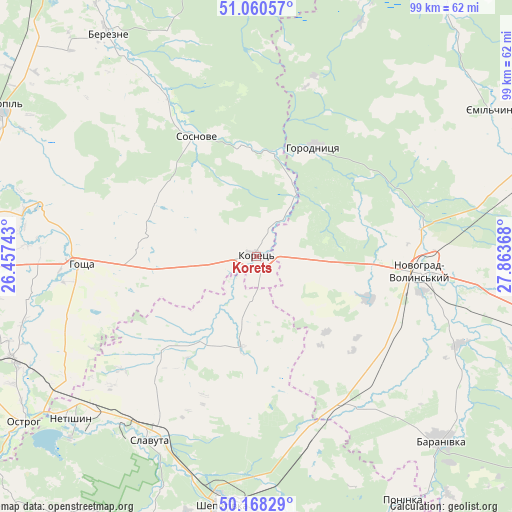
Korets GPS coordinates[2]
50° 36' 59.58" North, 27° 9' 37.98" East
| Map corner | latitude | longitude |
|---|---|---|
| Upper-left | 51.06057°, | 26.45743° |
| Center: | 50.61655°, | 27.16055° |
| Lower-right: | 50.16829°, | 27.86368° |
| Map W x H: | 99.2×99.2 km | = 61.6×61.6mi |
| max Lat: | 52.18903° ⇑7.4% North |
| Korets: | 50.61655° |
| min Lat: | ⇓92.6% South 44.39214° |
| min Long | Korets | max Long |
| 22.20555° | 27.16055° | 40.13222° |
| W 22.3%⇐ | ⇒77.7% E |
Elevation
Elevation of Korets is 214 m = 702 ft, and this is 58.2 m = 191 ft above average elevation for this country.
| Max E: |
886 m = 2907 ft | 27.8% |
| Korets | 214 m 702 ft | |
| Avg. | 155.8 m = 511 ft | |
Min E: |
-3 m = -10 ft | 72.2% |
See also: Ukraine elevation on elevation.city.
Geographical zone
Korets is located in North temperate zone (between Tropic of Cancer and the Arctic Circle). Distance of this North polar circle is 1773.1 km =1101.8 mi to North.| Distance of | km | miles | from Korets |
|---|---|---|---|
| North Pole | 4379 | 2721 | to North |
| Arctic Circle | 1773.1 | 1101.8 | to North |
| Tropic Cancer | 3022.1 | 1877.8 | to South |
| Equator | 5628 | 3497.1 | to South |


Nearby cities:
15 places around Korets: (largest is in red/bold)
• Baranivka
50.2 km =31.2 mi,  135°
135°
• Berezne
51.5 km =32 mi,  326°
326°
• Horodnytsya
23.9 km =14.9 mi,  27°
27°
• Hoshcha
34.4 km =21.4 mi,  266°
266°
• Hubkiv
24.9 km =15.5 mi,  341°
341°
• Koloniya Zastav’ye
24 km =14.9 mi, 338°
• Netishyn
47.9 km =29.8 mi,  230°
230°
• Novohrad-Volynskyi
32.3 km =20.1 mi,  94°
94°
• Ostroh
55.8 km =34.7 mi,  235°
235°
• Polyanka
54.6 km =33.9 mi, 136°
• Poninka
54.9 km =34.1 mi,  150°
150°
• Shepetivka
48.4 km =30.1 mi,  188°
188°
• Slavuta
40.8 km =25.4 mi,  210°
210°
• Velyki Mezhyrichi
21.2 km =13.2 mi,  281°
281°
• Yemil’chyne
53.7 km =33.4 mi,  57°
57°
Sources, notices
• [Note1] Compared only with cities in Ukraine existing in our database
• [Src1] Map data: © OpenStreetMap contributors (CC-BY-SA)
• [Src2] Other city data from geonames.org with taken over terms of usage.
• [Src3] Geographical zone / Annual Mean Temperature by Robert A. Rohde @ Wikipedia
