Niva geodata
Niva (Republic of Crimea) is a populated place; located in Ukraine in Europe/Simferopol (GMT+3) time zone. With population of 591 people, there are 1591 cities with bigger population in this country. Compared to other cities in Ukraine, 75.6% of cities are located further ↑North; 50.6% of cities are located further →East and 73.5% of cities have higher elevation than Niva. Note1
Administrative division(s):
- Level 1: Republic of Crimea
- Level 2: Razdol’nenskiy rayon
- Level 3: Berezovskoye sel'skoye poselenye


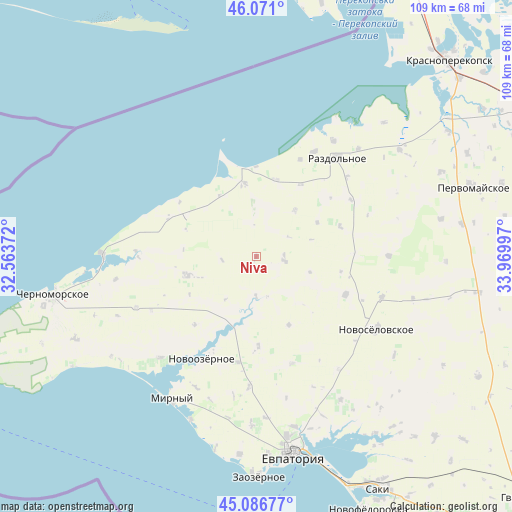
Niva GPS coordinates[2]
45° 34' 51.744" North, 33° 16' 0.624" East
| Map corner | latitude | longitude |
|---|---|---|
| Upper-left | 46.071°, | 32.56372° |
| Center: | 45.58104°, | 33.26684° |
| Lower-right: | 45.08677°, | 33.96997° |
| Map W x H: | 109.4×109.4 km | = 68×68mi |
| max Lat: | 52.18903° ⇑75.6% North |
| Niva: | 45.58104° |
| min Lat: | ⇓24.4% South 44.39214° |
| min Long | Niva | max Long |
| 22.20555° | 33.26684° | 40.13222° |
| W 49.4%⇐ | ⇒50.6% E |
Elevation
Elevation of Niva is 66 m = 217 ft, and this is 89.8 m = 295 ft below average elevation for this country.
| Max E: |
886 m = 2907 ft | 73.5% |
| Avg. | 155.8 m = 511 ft | |
| Niva | 66 m = 217 ft | |
Min E: |
-3 m = -10 ft | 26.5% |
See also: Ukraine elevation on elevation.city.
Geographical zone
Niva is located in North temperate zone (between Tropic of Cancer and the Arctic Circle). Distance of this North polar circle is 2333 km =1449.7 mi to North.| Distance of | km | miles | from Niva |
|---|---|---|---|
| North Pole | 4938.9 | 3068.9 | to North |
| Arctic Circle | 2333 | 1449.7 | to North |
| Tropic Cancer | 2462.2 | 1529.9 | to South |
| Equator | 5068.1 | 3149.2 | to South |


Nearby cities:
15 places around Niva: (largest is in red/bold)
• Berezovka
6 km =3.7 mi,  96°
96°
• Dalekoye
16.9 km =10.5 mi,  301°
301°
• Kirovskoye
15.3 km =9.5 mi,  254°
254°
• Krasnoyarskoye
8.3 km =5.2 mi,  180°
180°
• Kukushkino
18.1 km =11.2 mi,  31°
31°
• Natashino
19.2 km =11.9 mi, 178°
• Novoivanovka
19.7 km =12.2 mi,  221°
221°
• Ogni
22.7 km =14.1 mi,  24°
24°
• Orlovka
12.8 km =8 mi,  40°
40°
• Serebryanka
19 km =11.8 mi,  70°
70°
• Slavnoye
15.8 km =9.8 mi,  351°
351°
• Slavyanskoye
16.9 km =10.5 mi,  14°
14°
• Veselovka
23 km =14.3 mi,  190°
190°
• Yelizavetovo
16.3 km =10.1 mi,  154°
154°
• Zimino
20.9 km =13 mi,  112°
112°
Sources, notices
• [Note1] Compared only with cities in Ukraine existing in our database
• [Src1] Map data: © OpenStreetMap contributors (CC-BY-SA)
• [Src2] Other city data from geonames.org with taken over terms of usage.
• [Src3] Geographical zone / Annual Mean Temperature by Robert A. Rohde @ Wikipedia
