Liutizh geodata
Liutizh (Kyiv) is a populated place; located in Ukraine in Europe/Kiev (GMT+3) time zone. With population of 2,282 people, there are 1062 cities with bigger population in this country. Compared to other cities in Ukraine, 93.3% of cities are located further ↓South; 65.2% of cities are located further →East and 58.1% of cities have higher elevation than Liutizh. Note1


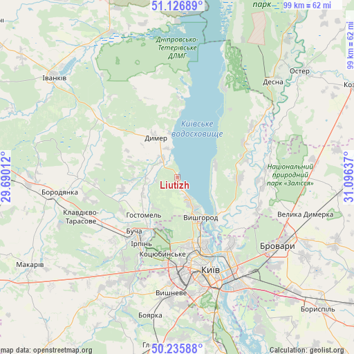
Liutizh GPS coordinates[2]
50° 41' 0.6" North, 30° 23' 35.664" East
| Map corner | latitude | longitude |
|---|---|---|
| Upper-left | 51.12689°, | 29.69012° |
| Center: | 50.6835°, | 30.39324° |
| Lower-right: | 50.23588°, | 31.09637° |
| Map W x H: | 99.1×99.1 km | = 61.6×61.6mi |
| max Lat: | 52.18903° ⇑6.7% North |
| Liutizh: | 50.6835° |
| min Lat: | ⇓93.3% South 44.39214° |
| min Long | Liutizh | max Long |
| 22.20555° | 30.39324° | 40.13222° |
| W 34.8%⇐ | ⇒65.2% E |
Elevation
Elevation of Liutizh is 112 m = 367 ft, and this is 43.8 m = 144 ft below average elevation for this country.
| Max E: |
886 m = 2907 ft | 58.1% |
| Avg. | 155.8 m = 511 ft | |
| Liutizh | 112 m = 367 ft | |
Min E: |
-3 m = -10 ft | 41.9% |
See also: Ukraine elevation on elevation.city.
Geographical zone
Liutizh is located in North temperate zone (between Tropic of Cancer and the Arctic Circle). Distance of this North polar circle is 1765.7 km =1097.2 mi to North.| Distance of | km | miles | from Liutizh |
|---|---|---|---|
| North Pole | 4371.6 | 2716.4 | to North |
| Arctic Circle | 1765.7 | 1097.2 | to North |
| Tropic Cancer | 3029.6 | 1882.5 | to South |
| Equator | 5635.5 | 3501.7 | to South |


Nearby cities:
15 places around Liutizh: (largest is in red/bold)
• Bucha
20.1 km =12.5 mi,  219°
219°
• Dymer
13.1 km =8.1 mi,  330°
330°
• Horenka
14.7 km =9.1 mi,  197°
197°
• Hostomel
15.7 km =9.8 mi, 215°
• Irpin
20.6 km =12.8 mi,  209°
209°
• Katyuzhanka
22.6 km =14 mi,  307°
307°
• Khotyanivka
15.8 km =9.8 mi,  127°
127°
• Klavdiyevo-Tarasove
29.1 km =18.1 mi,  247°
247°
• Kotsyubyns’ke
22.2 km =13.8 mi,  191°
191°
• Kyiv
27.1 km =16.8 mi,  160°
160°
• Novi Petrivtsi
7.1 km =4.4 mi,  150°
150°
• Pohreby
22.8 km =14.2 mi, 128°
• Pukhivka
24.3 km =15.1 mi,  109°
109°
• Vorzel’
22.9 km =14.2 mi,  227°
227°
• Vyshhorod
12.9 km =8 mi, 148°
Sources, notices
• [Note1] Compared only with cities in Ukraine existing in our database
• [Src1] Map data: © OpenStreetMap contributors (CC-BY-SA)
• [Src2] Other city data from geonames.org with taken over terms of usage.
• [Src3] Geographical zone / Annual Mean Temperature by Robert A. Rohde @ Wikipedia
