Katyuzhanka geodata
Katyuzhanka (Kyiv) is a populated place; located in Ukraine in Europe/Kiev (GMT+3) time zone. With population of 4,046 people, there are 757 cities with bigger population in this country. Compared to other cities in Ukraine, 94.3% of cities are located further ↓South; 67.1% of cities are located further →East and 50.9% of cities have lower elevation than Katyuzhanka. Note1


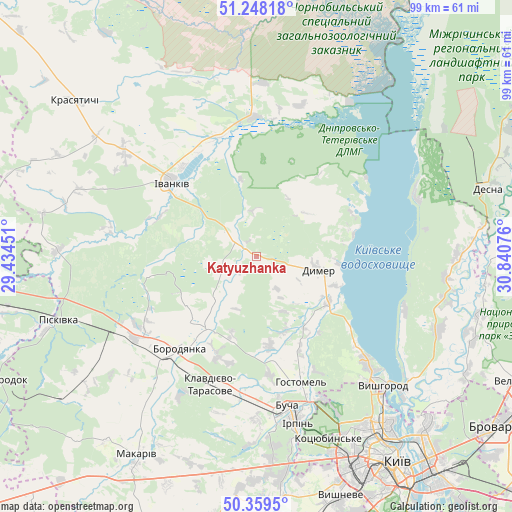
Katyuzhanka GPS coordinates[2]
50° 48' 21.42" North, 30° 8' 15.468" East
| Map corner | latitude | longitude |
|---|---|---|
| Upper-left | 51.24818°, | 29.43451° |
| Center: | 50.80595°, | 30.13763° |
| Lower-right: | 50.3595°, | 30.84076° |
| Map W x H: | 98.8×98.8 km | = 61.4×61.4mi |
| max Lat: | 52.18903° ⇑5.7% North |
| Katyuzhanka: | 50.80595° |
| min Lat: | ⇓94.3% South 44.39214° |
| min Long | Katyuzhanka | max Long |
| 22.20555° | 30.13763° | 40.13222° |
| W 32.9%⇐ | ⇒67.1% E |
Elevation
Elevation of Katyuzhanka is 139 m = 456 ft, and this is 16.8 m = 55 ft below average elevation for this country.
| Max E: |
886 m = 2907 ft | 49.1% |
| Avg. | 155.8 m = 511 ft | |
| Katyuzhanka | 139 m = 456 ft | |
Min E: |
-3 m = -10 ft | 50.9% |
See also: Ukraine elevation on elevation.city.
Geographical zone
Katyuzhanka is located in North temperate zone (between Tropic of Cancer and the Arctic Circle). Distance of this North polar circle is 1752.1 km =1088.7 mi to North.| Distance of | km | miles | from Katyuzhanka |
|---|---|---|---|
| North Pole | 4358 | 2707.9 | to North |
| Arctic Circle | 1752.1 | 1088.7 | to North |
| Tropic Cancer | 3043.2 | 1891 | to South |
| Equator | 5649.1 | 3510.2 | to South |


Nearby cities:
15 places around Katyuzhanka: (largest is in red/bold)
• Borodianka
23.6 km =14.7 mi,  220°
220°
• Bucha
29.7 km =18.5 mi,  169°
169°
• Dymer
11.8 km =7.3 mi,  100°
100°
• Horenka
30.9 km =19.2 mi,  153°
153°
• Hostomel
27.9 km =17.3 mi,  161°
161°
• Irpin
32.6 km =20.3 mi, 165°
• Ivankiv
22.6 km =14 mi,  310°
310°
• Khotyanivka
38.4 km =23.9 mi,  127°
127°
• Klavdiyevo-Tarasove
26.2 km =16.3 mi,  199°
199°
• Kotsyubyns’ke
37.8 km =23.5 mi, 159°
• Liutizh
22.6 km =14 mi, 127°
• Novi Petrivtsi
29.3 km =18.2 mi, 132°
• Piskivka
38.5 km =23.9 mi,  251°
251°
• Vorzel’
29.1 km =18.1 mi,  177°
177°
• Vyshhorod
34.9 km =21.7 mi, 134°
Sources, notices
• [Note1] Compared only with cities in Ukraine existing in our database
• [Src1] Map data: © OpenStreetMap contributors (CC-BY-SA)
• [Src2] Other city data from geonames.org with taken over terms of usage.
• [Src3] Geographical zone / Annual Mean Temperature by Robert A. Rohde @ Wikipedia
