Koreiz geodata
Koreiz (Republic of Crimea) is a populated place; located in Ukraine in Europe/Simferopol (GMT+3) time zone. With population of 5,455 people, there are 611 cities with bigger population in this country. Compared to other cities in Ukraine, 99.7% of cities are located further ↑North; 65.2% of cities are located further ←West and 60.6% of cities have lower elevation than Koreiz. Note1


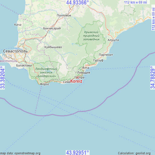
Koreiz GPS coordinates[2]
44° 26' 1.464" North, 34° 5' 6.576" East
| Map corner | latitude | longitude |
|---|---|---|
| Upper-left | 44.93366°, | 33.38204° |
| Center: | 44.43374°, | 34.08516° |
| Lower-right: | 43.92951°, | 34.78829° |
| Map W x H: | 111.7×111.6 km | = 69.4×69.3mi |
| max Lat: | 52.18903° ⇑99.7% North |
| Koreiz: | 44.43374° |
| min Lat: | ⇓0.3% South 44.39214° |
| min Long | Koreiz | max Long |
| 22.20555° | 34.08516° | 40.13222° |
| W 65.2%⇐ | ⇒34.8% E |
Elevation
Elevation of Koreiz is 170 m = 558 ft, and this is 14.2 m = 47 ft above average elevation for this country.
| Max E: |
886 m = 2907 ft | 39.4% |
| Koreiz | 170 m 558 ft | |
| Avg. | 155.8 m = 511 ft | |
Min E: |
-3 m = -10 ft | 60.6% |
See also: Ukraine elevation on elevation.city.
Geographical zone
Koreiz is located in North temperate zone (between Tropic of Cancer and the Arctic Circle). Distance of this Northern Tropic circle is 2334.6 km =1450.7 mi to South.| Distance of | km | miles | from Koreiz |
|---|---|---|---|
| North Pole | 5066.5 | 3148.2 | to North |
| Arctic Circle | 2460.6 | 1528.9 | to North |
| Tropic Cancer | 2334.6 | 1450.7 | to South |
| Equator | 4940.6 | 3069.9 | to South |


Nearby cities:
15 places around Koreiz: (largest is in red/bold)
• Alupka
3.6 km =2.2 mi,  241°
241°
• Gaspra
1.4 km =0.9 mi,  90°
90°
• Goluboy Zaliv
8.2 km =5.1 mi,  252°
252°
• Katsiveli
9.9 km =6.2 mi, 244°
• Livadia
6.1 km =3.8 mi,  48°
48°
• Massandra
11.7 km =7.3 mi,  44°
44°
• Nikita
15.2 km =9.4 mi, 53°
• Oreanda
5.1 km =3.2 mi,  59°
59°
• Otradnoye
12.8 km =8 mi, 51°
• Rodnikovoye
18.8 km =11.7 mi,  280°
280°
• Simeiz
6.9 km =4.3 mi, 243°
• Sokolinoye
16.4 km =10.2 mi,  322°
322°
• Sovetskoye
13.8 km =8.6 mi, 35°
• Vinogradnoye
6.4 km =4 mi,  33°
33°
• Yalta
10 km =6.2 mi, 40°
Sources, notices
• [Note1] Compared only with cities in Ukraine existing in our database
• [Src1] Map data: © OpenStreetMap contributors (CC-BY-SA)
• [Src2] Other city data from geonames.org with taken over terms of usage.
• [Src3] Geographical zone / Annual Mean Temperature by Robert A. Rohde @ Wikipedia
