Alupka geodata
Alupka (Republic of Crimea) is a populated place; located in Ukraine in Europe/Simferopol (GMT+3) time zone. With population of 7,849 people, there are 453 cities with bigger population in this country. Compared to other cities in Ukraine, 99.8% of cities are located further ↑North; 64% of cities are located further ←West and 66.9% of cities have higher elevation than Alupka. Note1


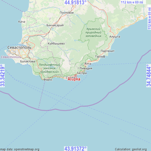
Alupka GPS coordinates[2]
44° 25' 5.088" North, 34° 2' 43.116" East
| Map corner | latitude | longitude |
|---|---|---|
| Upper-left | 44.91813°, | 33.34219° |
| Center: | 44.41808°, | 34.04531° |
| Lower-right: | 43.91372°, | 34.74844° |
| Map W x H: | 111.7×111.7 km | = 69.4×69.4mi |
| max Lat: | 52.18903° ⇑99.8% North |
| Alupka: | 44.41808° |
| min Lat: | ⇓0.2% South 44.39214° |
| min Long | Alupka | max Long |
| 22.20555° | 34.04531° | 40.13222° |
| W 64%⇐ | ⇒36% E |
Elevation
Elevation of Alupka is 84 m = 276 ft, and this is 71.8 m = 236 ft below average elevation for this country.
| Max E: |
886 m = 2907 ft | 66.9% |
| Avg. | 155.8 m = 511 ft | |
| Alupka | 84 m = 276 ft | |
Min E: |
-3 m = -10 ft | 33.1% |
See also: Ukraine elevation on elevation.city.
Geographical zone
Alupka is located in North temperate zone (between Tropic of Cancer and the Arctic Circle). Distance of this Northern Tropic circle is 2332.9 km =1449.6 mi to South.| Distance of | km | miles | from Alupka |
|---|---|---|---|
| North Pole | 5068.2 | 3149.2 | to North |
| Arctic Circle | 2462.3 | 1530 | to North |
| Tropic Cancer | 2332.9 | 1449.6 | to South |
| Equator | 4938.8 | 3068.8 | to South |


Nearby cities:
15 places around Alupka: (largest is in red/bold)
• Gaspra
4.9 km =3 mi,  69°
69°
• Goluboy Zaliv
4.7 km =2.9 mi,  260°
260°
• Katsiveli
6.3 km =3.9 mi,  246°
246°
• Koreiz
3.6 km =2.2 mi,  61°
61°
• Livadia
9.7 km =6 mi,  53°
53°
• Massandra
15.2 km =9.4 mi, 48°
• Nikita
18.8 km =11.7 mi, 54°
• Oreanda
8.7 km =5.4 mi, 60°
• Otradnoye
16.3 km =10.1 mi, 53°
• Rodnikovoye
16.2 km =10.1 mi,  288°
288°
• Simeiz
3.3 km =2.1 mi, 246°
• Sokolinoye
16.2 km =10.1 mi,  335°
335°
• Sovetskoye
17.1 km =10.6 mi,  41°
41°
• Vinogradnoye
9.7 km =6 mi, 43°
• Yalta
13.4 km =8.3 mi, 45°
Sources, notices
• [Note1] Compared only with cities in Ukraine existing in our database
• [Src1] Map data: © OpenStreetMap contributors (CC-BY-SA)
• [Src2] Other city data from geonames.org with taken over terms of usage.
• [Src3] Geographical zone / Annual Mean Temperature by Robert A. Rohde @ Wikipedia
