Sokolinoye geodata
Sokolinoye (Republic of Crimea) is a populated place; located in Ukraine in Europe/Simferopol (GMT+3) time zone. With population of 1,251 people, there are 1281 cities with bigger population in this country. Compared to other cities in Ukraine, 98.5% of cities are located further ↑North; 61.5% of cities are located further ←West and 84.4% of cities have lower elevation than Sokolinoye. Note1
Administrative division(s):
- Level 1: Republic of Crimea
- Level 2: Bakhchysarai Raion
- Level 3: Golubinskoye sel'skoye poselenye


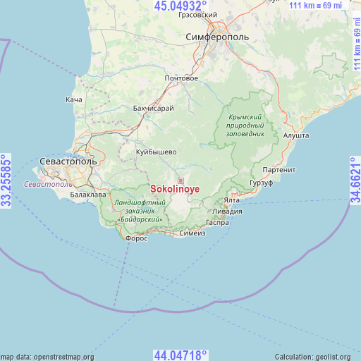
Sokolinoye GPS coordinates[2]
44° 33' 1.476" North, 33° 57' 32.292" East
| Map corner | latitude | longitude |
|---|---|---|
| Upper-left | 45.04932°, | 33.25585° |
| Center: | 44.55041°, | 33.95897° |
| Lower-right: | 44.04718°, | 34.6621° |
| Map W x H: | 111.4×111.4 km | = 69.2×69.2mi |
| max Lat: | 52.18903° ⇑98.5% North |
| Sokolinoye: | 44.55041° |
| min Lat: | ⇓1.5% South 44.39214° |
| min Long | Sokolinoye | max Long |
| 22.20555° | 33.95897° | 40.13222° |
| W 61.5%⇐ | ⇒38.5% E |
Elevation
Elevation of Sokolinoye is 270 m = 886 ft, and this is 114.2 m = 375 ft above average elevation for this country.
| Max E: |
886 m = 2907 ft | 15.6% |
| Sokolinoye | 270 m 886 ft | |
| Avg. | 155.8 m = 511 ft | |
Min E: |
-3 m = -10 ft | 84.4% |
See also: Ukraine elevation on elevation.city.
Geographical zone
Sokolinoye is located in North temperate zone (between Tropic of Cancer and the Arctic Circle). Distance of this Northern Tropic circle is 2347.6 km =1458.7 mi to South.| Distance of | km | miles | from Sokolinoye |
|---|---|---|---|
| North Pole | 5053.5 | 3140.1 | to North |
| Arctic Circle | 2447.6 | 1520.9 | to North |
| Tropic Cancer | 2347.6 | 1458.7 | to South |
| Equator | 4953.5 | 3078 | to South |


Nearby cities:
15 places around Sokolinoye: (largest is in red/bold)
• Alupka
16.2 km =10.1 mi,  155°
155°
• Golubinka
5.9 km =3.7 mi,  324°
324°
• Goluboy Zaliv
15.6 km =9.7 mi,  172°
172°
• Koreiz
16.4 km =10.2 mi,  142°
142°
• Kuibyshevo
11.3 km =7 mi, 320°
• Peredovoye
11.3 km =7 mi,  246°
246°
• Plotinnoye
4.1 km =2.5 mi,  7°
7°
• Rodnikovoye
12.8 km =8 mi,  221°
221°
• Shirokoye
17 km =10.6 mi,  242°
242°
• Simeiz
16.5 km =10.3 mi, 166°
• Tankovoye
16.9 km =10.5 mi, 315°
• Ternovka
16.8 km =10.4 mi,  281°
281°
• Verkhorechye
16.5 km =10.3 mi, 7°
• Vinogradnoye
15.6 km =9.7 mi,  119°
119°
• Zelyonoye
6.4 km =4 mi,  38°
38°
Sources, notices
• [Note1] Compared only with cities in Ukraine existing in our database
• [Src1] Map data: © OpenStreetMap contributors (CC-BY-SA)
• [Src2] Other city data from geonames.org with taken over terms of usage.
• [Src3] Geographical zone / Annual Mean Temperature by Robert A. Rohde @ Wikipedia
