Massandra geodata
Massandra (Republic of Crimea) is a populated place; located in Ukraine in Europe/Simferopol (GMT+3) time zone. With population of 7,280 people, there are 493 cities with bigger population in this country. Compared to other cities in Ukraine, 99% of cities are located further ↑North; 67.3% of cities are located further ←West and 72.9% of cities have lower elevation than Massandra. Note1


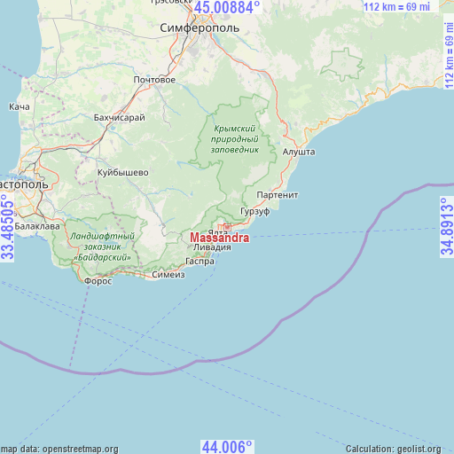
Massandra GPS coordinates[2]
44° 30' 34.488" North, 34° 11' 17.412" East
| Map corner | latitude | longitude |
|---|---|---|
| Upper-left | 45.00884°, | 33.48505° |
| Center: | 44.50958°, | 34.18817° |
| Lower-right: | 44.006°, | 34.8913° |
| Map W x H: | 111.5×111.5 km | = 69.3×69.3mi |
| max Lat: | 52.18903° ⇑99% North |
| Massandra: | 44.50958° |
| min Lat: | ⇓1% South 44.39214° |
| min Long | Massandra | max Long |
| 22.20555° | 34.18817° | 40.13222° |
| W 67.3%⇐ | ⇒32.7% E |
Elevation
Elevation of Massandra is 216 m = 709 ft, and this is 60.2 m = 198 ft above average elevation for this country.
| Max E: |
886 m = 2907 ft | 27.1% |
| Massandra | 216 m 709 ft | |
| Avg. | 155.8 m = 511 ft | |
Min E: |
-3 m = -10 ft | 72.9% |
See also: Ukraine elevation on elevation.city.
Geographical zone
Massandra is located in North temperate zone (between Tropic of Cancer and the Arctic Circle). Distance of this Northern Tropic circle is 2343.1 km =1455.9 mi to South.| Distance of | km | miles | from Massandra |
|---|---|---|---|
| North Pole | 5058.1 | 3143 | to North |
| Arctic Circle | 2452.2 | 1523.7 | to North |
| Tropic Cancer | 2343.1 | 1455.9 | to South |
| Equator | 4949 | 3075.2 | to South |


Nearby cities:
15 places around Massandra: (largest is in red/bold)
• Alupka
15.2 km =9.4 mi,  228°
228°
• Gaspra
10.8 km =6.7 mi,  218°
218°
• Gurzuf
8.2 km =5.1 mi,  60°
60°
• Koreiz
11.7 km =7.3 mi, 224°
• Krasnokamenka
10 km =6.2 mi,  52°
52°
• Livadia
5.7 km =3.5 mi, 219°
• Nikita
4 km =2.5 mi,  80°
80°
• Oreanda
6.9 km =4.3 mi,  212°
212°
• Otradnoye
1.9 km =1.2 mi,  106°
106°
• Partenit
14.5 km =9 mi, 58°
• Sovetskoye
2.7 km =1.7 mi,  358°
358°
• Vinogradnoye
5.6 km =3.5 mi,  236°
236°
• Yalta
1.9 km =1.2 mi, 244°
• Zaprudnoye
13.8 km =8.6 mi, 48°
• Zelyonoye
17.1 km =10.6 mi,  304°
304°
Sources, notices
• [Note1] Compared only with cities in Ukraine existing in our database
• [Src1] Map data: © OpenStreetMap contributors (CC-BY-SA)
• [Src2] Other city data from geonames.org with taken over terms of usage.
• [Src3] Geographical zone / Annual Mean Temperature by Robert A. Rohde @ Wikipedia
