Simeiz geodata
Simeiz (Republic of Crimea) is a populated place; located in Ukraine in Europe/Simferopol (GMT+3) time zone. With population of 2,604 people, there are 1014 cities with bigger population in this country. Compared to other cities in Ukraine, 99.9% of cities are located further ↑North; 62.9% of cities are located further ←West and 70% of cities have higher elevation than Simeiz. Note1


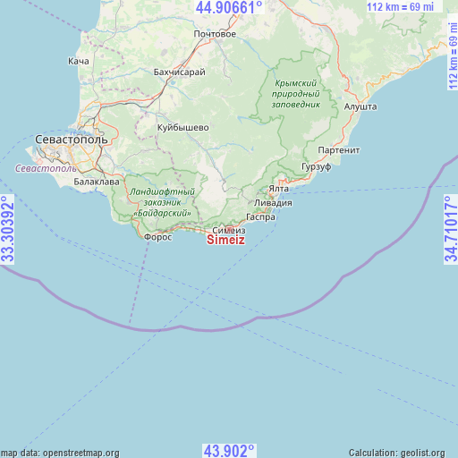
Simeiz GPS coordinates[2]
44° 24' 23.256" North, 34° 0' 25.344" East
| Map corner | latitude | longitude |
|---|---|---|
| Upper-left | 44.90661°, | 33.30392° |
| Center: | 44.40646°, | 34.00704° |
| Lower-right: | 43.902°, | 34.71017° |
| Map W x H: | 111.7×111.7 km | = 69.4×69.4mi |
| max Lat: | 52.18903° ⇑99.9% North |
| Simeiz: | 44.40646° |
| min Lat: | ⇓0.1% South 44.39214° |
| min Long | Simeiz | max Long |
| 22.20555° | 34.00704° | 40.13222° |
| W 62.9%⇐ | ⇒37.1% E |
Elevation
Elevation of Simeiz is 75 m = 246 ft, and this is 80.8 m = 265 ft below average elevation for this country.
| Max E: |
886 m = 2907 ft | 70% |
| Avg. | 155.8 m = 511 ft | |
| Simeiz | 75 m = 246 ft | |
Min E: |
-3 m = -10 ft | 30% |
See also: Ukraine elevation on elevation.city.
Geographical zone
Simeiz is located in North temperate zone (between Tropic of Cancer and the Arctic Circle). Distance of this Northern Tropic circle is 2331.6 km =1448.8 mi to South.| Distance of | km | miles | from Simeiz |
|---|---|---|---|
| North Pole | 5069.5 | 3150 | to North |
| Arctic Circle | 2463.6 | 1530.8 | to North |
| Tropic Cancer | 2331.6 | 1448.8 | to South |
| Equator | 4937.5 | 3068 | to South |


Nearby cities:
15 places around Simeiz: (largest is in red/bold)
• Alupka
3.3 km =2.1 mi,  66°
66°
• Foros
17.5 km =10.9 mi,  264°
264°
• Gaspra
8.2 km =5.1 mi, 68°
• Goluboy Zaliv
1.7 km =1.1 mi,  287°
287°
• Katsiveli
3 km =1.9 mi,  245°
245°
• Koreiz
6.9 km =4.3 mi,  63°
63°
• Livadia
12.9 km =8 mi, 56°
• Massandra
18.4 km =11.4 mi,  51°
51°
• Oreanda
12 km =7.5 mi, 62°
• Orlinoye
18.9 km =11.7 mi,  283°
283°
• Peredovoye
18.2 km =11.3 mi,  309°
309°
• Rodnikovoye
13.9 km =8.6 mi,  297°
297°
• Sokolinoye
16.5 km =10.3 mi,  346°
346°
• Vinogradnoye
12.8 km =8 mi, 49°
• Yalta
16.5 km =10.3 mi, 49°
Sources, notices
• [Note1] Compared only with cities in Ukraine existing in our database
• [Src1] Map data: © OpenStreetMap contributors (CC-BY-SA)
• [Src2] Other city data from geonames.org with taken over terms of usage.
• [Src3] Geographical zone / Annual Mean Temperature by Robert A. Rohde @ Wikipedia
