Gurzuf geodata
Gurzuf (Republic of Crimea) is a populated place; located in Ukraine in Europe/Simferopol (GMT+3) time zone. With population of 8,933 people, there are 401 cities with bigger population in this country. Compared to other cities in Ukraine, 98.6% of cities are located further ↑North; 69% of cities are located further ←West and 68% of cities have higher elevation than Gurzuf. Note1


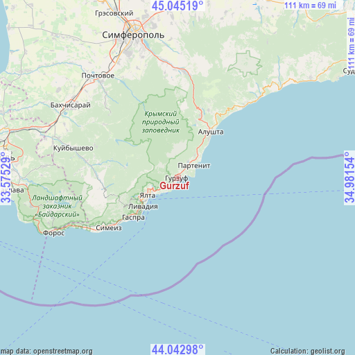
Gurzuf GPS coordinates[2]
44° 32' 46.464" North, 34° 16' 42.276" East
| Map corner | latitude | longitude |
|---|---|---|
| Upper-left | 45.04519°, | 33.57529° |
| Center: | 44.54624°, | 34.27841° |
| Lower-right: | 44.04298°, | 34.98154° |
| Map W x H: | 111.4×111.4 km | = 69.2×69.2mi |
| max Lat: | 52.18903° ⇑98.6% North |
| Gurzuf: | 44.54624° |
| min Lat: | ⇓1.4% South 44.39214° |
| min Long | Gurzuf | max Long |
| 22.20555° | 34.27841° | 40.13222° |
| W 69%⇐ | ⇒31% E |
Elevation
Elevation of Gurzuf is 81 m = 266 ft, and this is 74.8 m = 245 ft below average elevation for this country.
| Max E: |
886 m = 2907 ft | 68% |
| Avg. | 155.8 m = 511 ft | |
| Gurzuf | 81 m = 266 ft | |
Min E: |
-3 m = -10 ft | 32% |
See also: Ukraine elevation on elevation.city.
Geographical zone
Gurzuf is located in North temperate zone (between Tropic of Cancer and the Arctic Circle). Distance of this Northern Tropic circle is 2347.2 km =1458.5 mi to South.| Distance of | km | miles | from Gurzuf |
|---|---|---|---|
| North Pole | 5054 | 3140.4 | to North |
| Arctic Circle | 2448.1 | 1521.2 | to North |
| Tropic Cancer | 2347.2 | 1458.5 | to South |
| Equator | 4953.1 | 3077.7 | to South |


Nearby cities:
15 places around Gurzuf: (largest is in red/bold)
• Alushta
17.9 km =11.1 mi,  35°
35°
• Gaspra
18.7 km =11.6 mi,  228°
228°
• Izobil’noye
18.4 km =11.4 mi,  18°
18°
• Krasnokamenka
2.1 km =1.3 mi, 22°
• Livadia
13.7 km =8.5 mi, 231°
• Maly Mayak
10.1 km =6.3 mi, 42°
• Massandra
8.2 km =5.1 mi,  240°
240°
• Nikita
4.7 km =2.9 mi,  222°
222°
• Oreanda
14.7 km =9.1 mi, 227°
• Otradnoye
7 km =4.3 mi, 229°
• Partenit
6.3 km =3.9 mi,  56°
56°
• Sovetskoye
7.3 km =4.5 mi,  259°
259°
• Vinogradnoye
13.8 km =8.6 mi, 238°
• Yalta
10.2 km =6.3 mi, 241°
• Zaprudnoye
6 km =3.7 mi,  31°
31°
Sources, notices
• [Note1] Compared only with cities in Ukraine existing in our database
• [Src1] Map data: © OpenStreetMap contributors (CC-BY-SA)
• [Src2] Other city data from geonames.org with taken over terms of usage.
• [Src3] Geographical zone / Annual Mean Temperature by Robert A. Rohde @ Wikipedia
